You are here: Home > Network List > US - United States National Seismic Network Stations List
> Station DGMT Dagmar, Montana, USA > Earthquake Result Viewer
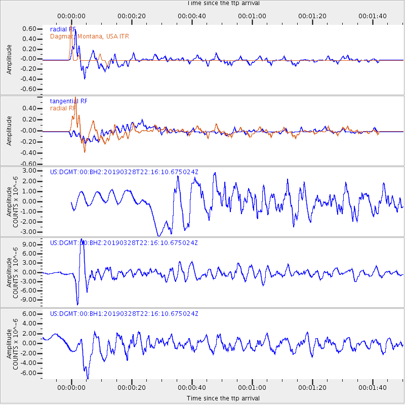
DGMT Dagmar, Montana, USA - Earthquake Result Viewer
*The percent match for this event was below the threshold and hence no stack was calculated.
| Earthquake location: |
East Of Kuril Islands |
| Earthquake latitude/longitude: |
50.5/160.0 |
| Earthquake time(UTC): |
2019/03/28 (087) 22:06:49 GMT |
| Earthquake Depth: |
9.0 km |
| Earthquake Magnitude: |
6.2 Mww |
| Earthquake Catalog/Contributor: |
NEIC PDE/us |
|
| Network: |
US United States National Seismic Network |
| Station: |
DGMT Dagmar, Montana, USA |
| Lat/Lon: |
48.47 N/104.20 W |
| Elevation: |
0.0 m |
|
| Distance: |
57.9 deg |
| Az: |
51.386 deg |
| Baz: |
311.429 deg |
| Ray Param: |
$rayparam |
*The percent match for this event was below the threshold and hence was not used in the summary stack. |
|
| Radial Match: |
82.1175 % |
| Radial Bump: |
400 |
| Transverse Match: |
28.092813 % |
| Transverse Bump: |
400 |
| SOD ConfigId: |
3426611 |
| Insert Time: |
2019-04-11 22:26:52.405 +0000 |
| GWidth: |
2.5 |
| Max Bumps: |
400 |
| Tol: |
0.001 |
|
Signal To Noise
| Channel | StoN | STA | LTA |
| US:DGMT:00:BHZ:20190328T22:16:10.675024Z | 30.922997 | 6.0404977E-6 | 1.9534E-7 |
| US:DGMT:00:BH1:20190328T22:16:10.675024Z | 3.2552485 | 2.517434E-6 | 7.733462E-7 |
| US:DGMT:00:BH2:20190328T22:16:10.675024Z | 5.2855115 | 2.7589822E-6 | 5.2198965E-7 |
| Arrivals |
| Ps | |
| PpPs | |
| PsPs/PpSs | |


