You are here: Home > Network List > TA - USArray Transportable Network (new EarthScope stations) Stations List
> Station 149A Jones, AL, USA > Earthquake Result Viewer
149A Jones, AL, USA - Earthquake Result Viewer
| Earthquake location: |
Salta Province, Argentina |
| Earthquake latitude/longitude: |
-22.1/-63.6 |
| Earthquake time(UTC): |
2012/06/02 (154) 07:52:53 GMT |
| Earthquake Depth: |
527 km |
| Earthquake Magnitude: |
5.8 MB, 5.9 MW, 6.0 MW |
| Earthquake Catalog/Contributor: |
WHDF/NEIC |
|
| Network: |
TA USArray Transportable Network (new EarthScope stations) |
| Station: |
149A Jones, AL, USA |
| Lat/Lon: |
32.60 N/86.79 W |
| Elevation: |
138 m |
|
| Distance: |
58.7 deg |
| Az: |
337.065 deg |
| Baz: |
154.642 deg |
| Ray Param: |
0.060581427 |
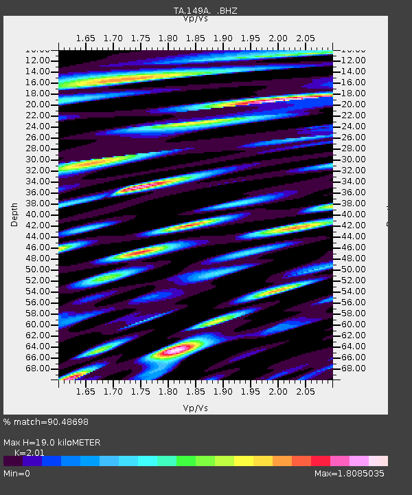
| Estimated Moho Depth: |
19.0 km |
| Estimated Crust Vp/Vs: |
2.01 |
| Assumed Crust Vp: |
6.565 km/s |
| Estimated Crust Vs: |
3.266 km/s |
| Estimated Crust Poisson's Ratio: |
0.34 |
|
| Radial Match: |
90.48698 % |
| Radial Bump: |
400 |
| Transverse Match: |
82.40221 % |
| Transverse Bump: |
400 |
| SOD ConfigId: |
455246 |
| Insert Time: |
2012-09-25 05:18:18.221 +0000 |
| GWidth: |
2.5 |
| Max Bumps: |
400 |
| Tol: |
0.001 |
|

Signal To Noise
| Channel | StoN | STA | LTA |
| TA:149A: :BHZ:20120602T08:01:30.12501Z | 14.552054 | 1.4967077E-6 | 1.02851985E-7 |
| TA:149A: :BHN:20120602T08:01:30.12501Z | 16.079767 | 1.7717769E-6 | 1.10186726E-7 |
| TA:149A: :BHE:20120602T08:01:30.12501Z | 10.004747 | 8.8184527E-7 | 8.8142684E-8 |
| Arrivals |
| Ps | 3.0 SECOND |
| PpPs | 8.4 SECOND |
| PsPs/PpSs | 11 SECOND |


