You are here: Home > Network List > US - United States National Seismic Network Stations List
> Station NATX Nacogdoches, Texas, USA > Earthquake Result Viewer
NATX Nacogdoches, Texas, USA - Earthquake Result Viewer

| Earthquake location: |
East Of Kuril Islands |
| Earthquake latitude/longitude: |
50.5/160.0 |
| Earthquake time(UTC): |
2019/03/28 (087) 22:06:49 GMT |
| Earthquake Depth: |
9.0 km |
| Earthquake Magnitude: |
6.2 Mww |
| Earthquake Catalog/Contributor: |
NEIC PDE/us |
|
| Network: |
US United States National Seismic Network |
| Station: |
NATX Nacogdoches, Texas, USA |
| Lat/Lon: |
31.76 N/94.66 W |
| Elevation: |
168 m |
|
| Distance: |
75.0 deg |
| Az: |
58.248 deg |
| Baz: |
320.397 deg |
| Ray Param: |
0.05196028 |
| Estimated Moho Depth: |
17.25 km |
| Estimated Crust Vp/Vs: |
1.60 |
| Assumed Crust Vp: |
5.738 km/s |
| Estimated Crust Vs: |
3.587 km/s |
| Estimated Crust Poisson's Ratio: |
0.18 |
|
| Radial Match: |
89.39217 % |
| Radial Bump: |
400 |
| Transverse Match: |
74.264465 % |
| Transverse Bump: |
400 |
| SOD ConfigId: |
3426611 |
| Insert Time: |
2019-04-11 22:27:36.228 +0000 |
| GWidth: |
2.5 |
| Max Bumps: |
400 |
| Tol: |
0.001 |
|
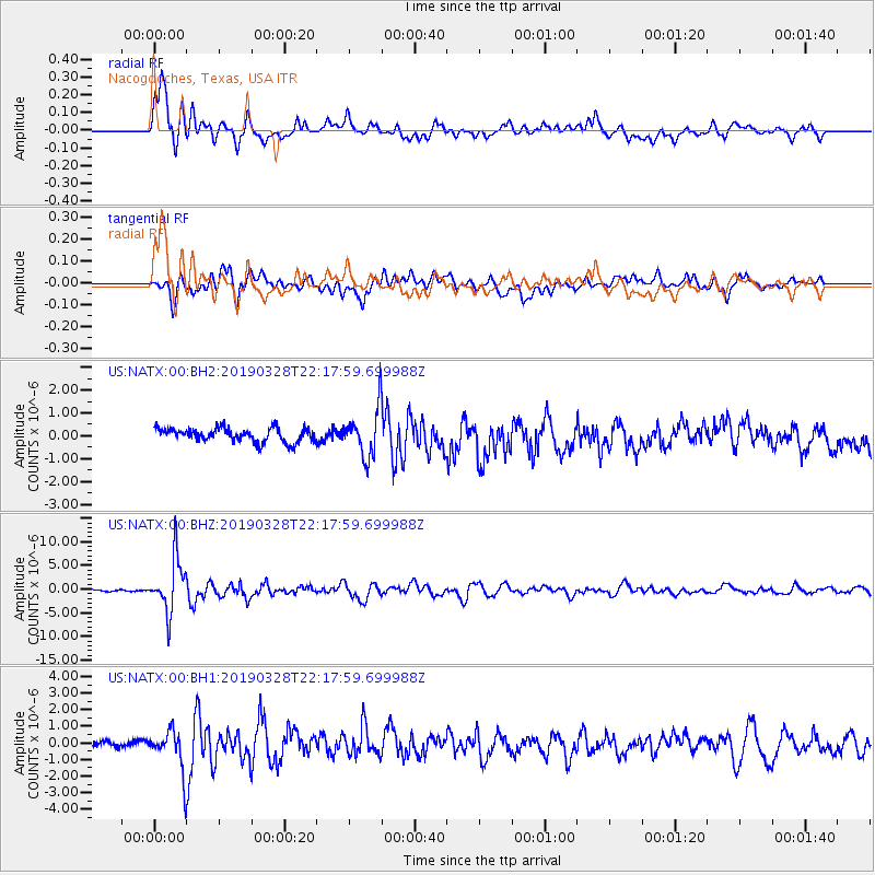
Signal To Noise
| Channel | StoN | STA | LTA |
| US:NATX:00:BHZ:20190328T22:17:59.699988Z | 34.02391 | 5.6111367E-6 | 1.6491745E-7 |
| US:NATX:00:BH1:20190328T22:17:59.699988Z | 5.7757187 | 1.2218719E-6 | 2.1155323E-7 |
| US:NATX:00:BH2:20190328T22:17:59.699988Z | 3.4747114 | 1.0498972E-6 | 3.0215378E-7 |
| Arrivals |
| Ps | 1.9 SECOND |
| PpPs | 7.6 SECOND |
| PsPs/PpSs | 9.5 SECOND |


