You are here: Home > Network List > TA - USArray Transportable Network (new EarthScope stations) Stations List
> Station V53A Saluda, NC, USA > Earthquake Result Viewer
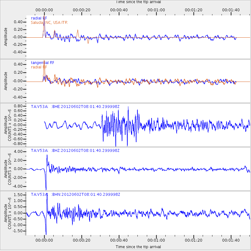
V53A Saluda, NC, USA - Earthquake Result Viewer
*The percent match for this event was below the threshold and hence no stack was calculated.
| Earthquake location: |
Salta Province, Argentina |
| Earthquake latitude/longitude: |
-22.1/-63.6 |
| Earthquake time(UTC): |
2012/06/02 (154) 07:52:53 GMT |
| Earthquake Depth: |
527 km |
| Earthquake Magnitude: |
5.8 MB, 5.9 MW, 6.0 MW |
| Earthquake Catalog/Contributor: |
WHDF/NEIC |
|
| Network: |
TA USArray Transportable Network (new EarthScope stations) |
| Station: |
V53A Saluda, NC, USA |
| Lat/Lon: |
35.67 N/82.81 W |
| Elevation: |
681 m |
|
| Distance: |
60.2 deg |
| Az: |
341.981 deg |
| Baz: |
159.364 deg |
| Ray Param: |
$rayparam |
*The percent match for this event was below the threshold and hence was not used in the summary stack. |
|
| Radial Match: |
77.0729 % |
| Radial Bump: |
400 |
| Transverse Match: |
70.05064 % |
| Transverse Bump: |
400 |
| SOD ConfigId: |
455246 |
| Insert Time: |
2012-09-25 05:24:22.493 +0000 |
| GWidth: |
2.5 |
| Max Bumps: |
400 |
| Tol: |
0.001 |
|
Signal To Noise
| Channel | StoN | STA | LTA |
| TA:V53A: :BHZ:20120602T08:01:40.299998Z | 11.473592 | 1.4914841E-6 | 1.2999278E-7 |
| TA:V53A: :BHN:20120602T08:01:40.299998Z | 6.0581894 | 5.9606907E-7 | 9.8390636E-8 |
| TA:V53A: :BHE:20120602T08:01:40.299998Z | 2.7502668 | 2.5517E-7 | 9.278009E-8 |
| Arrivals |
| Ps | |
| PpPs | |
| PsPs/PpSs | |


