You are here: Home > Network List > US - United States National Seismic Network Stations List
> Station SCIA State Center, Iowa, USA > Earthquake Result Viewer
SCIA State Center, Iowa, USA - Earthquake Result Viewer
| Earthquake location: |
East Of Kuril Islands |
| Earthquake latitude/longitude: |
50.5/160.0 |
| Earthquake time(UTC): |
2019/03/28 (087) 22:06:49 GMT |
| Earthquake Depth: |
9.0 km |
| Earthquake Magnitude: |
6.2 Mww |
| Earthquake Catalog/Contributor: |
NEIC PDE/us |
|
| Network: |
US United States National Seismic Network |
| Station: |
SCIA State Center, Iowa, USA |
| Lat/Lon: |
41.91 N/93.22 W |
| Elevation: |
312 m |
|
| Distance: |
68.0 deg |
| Az: |
50.396 deg |
| Baz: |
318.766 deg |
| Ray Param: |
0.056573268 |
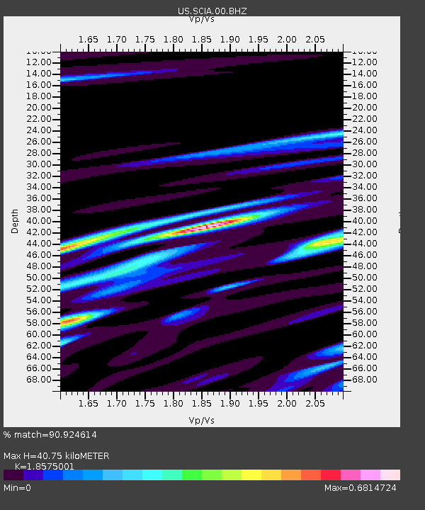
| Estimated Moho Depth: |
40.75 km |
| Estimated Crust Vp/Vs: |
1.86 |
| Assumed Crust Vp: |
6.498 km/s |
| Estimated Crust Vs: |
3.498 km/s |
| Estimated Crust Poisson's Ratio: |
0.30 |
|
| Radial Match: |
90.924614 % |
| Radial Bump: |
400 |
| Transverse Match: |
67.5681 % |
| Transverse Bump: |
400 |
| SOD ConfigId: |
3426611 |
| Insert Time: |
2019-04-11 22:27:49.275 +0000 |
| GWidth: |
2.5 |
| Max Bumps: |
400 |
| Tol: |
0.001 |
|
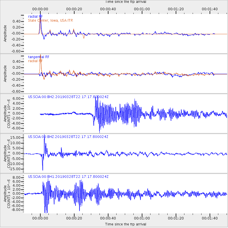
Signal To Noise
| Channel | StoN | STA | LTA |
| US:SCIA:00:BHZ:20190328T22:17:17.800024Z | 32.489807 | 6.1131323E-6 | 1.8815538E-7 |
| US:SCIA:00:BH1:20190328T22:17:17.800024Z | 16.84314 | 4.0260065E-6 | 2.3902945E-7 |
| US:SCIA:00:BH2:20190328T22:17:17.800024Z | 11.562651 | 2.710375E-6 | 2.3440775E-7 |
| Arrivals |
| Ps | 5.6 SECOND |
| PpPs | 17 SECOND |
| PsPs/PpSs | 23 SECOND |


