You are here: Home > Network List > UW - Pacific Northwest Regional Seismic Network Stations List
> Station MRBL Marblemount, WA, USA > Earthquake Result Viewer
MRBL Marblemount, WA, USA - Earthquake Result Viewer
*The percent match for this event was below the threshold and hence no stack was calculated.
| Earthquake location: |
Salta Province, Argentina |
| Earthquake latitude/longitude: |
-22.1/-63.6 |
| Earthquake time(UTC): |
2012/06/02 (154) 07:52:53 GMT |
| Earthquake Depth: |
527 km |
| Earthquake Magnitude: |
5.8 MB, 5.9 MW, 6.0 MW |
| Earthquake Catalog/Contributor: |
WHDF/NEIC |
|
| Network: |
UW Pacific Northwest Regional Seismic Network |
| Station: |
MRBL Marblemount, WA, USA |
| Lat/Lon: |
48.52 N/121.48 W |
| Elevation: |
75 m |
|
| Distance: |
87.2 deg |
| Az: |
325.662 deg |
| Baz: |
128.091 deg |
| Ray Param: |
$rayparam |
*The percent match for this event was below the threshold and hence was not used in the summary stack. |
|
| Radial Match: |
73.318115 % |
| Radial Bump: |
400 |
| Transverse Match: |
67.65574 % |
| Transverse Bump: |
400 |
| SOD ConfigId: |
455246 |
| Insert Time: |
2012-09-25 05:26:00.968 +0000 |
| GWidth: |
2.5 |
| Max Bumps: |
400 |
| Tol: |
0.001 |
|
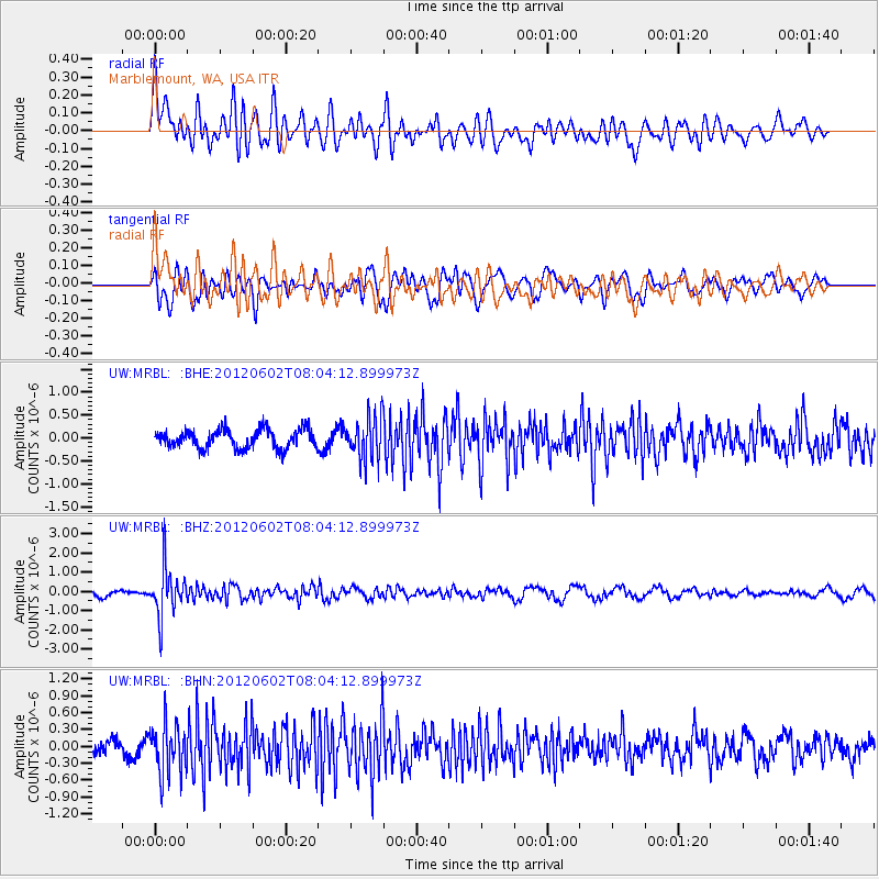
Signal To Noise
| Channel | StoN | STA | LTA |
| UW:MRBL: :BHZ:20120602T08:04:12.899973Z | 9.606431 | 1.2579604E-6 | 1.3094981E-7 |
| UW:MRBL: :BHN:20120602T08:04:12.899973Z | 2.7577684 | 4.4820524E-7 | 1.6252461E-7 |
| UW:MRBL: :BHE:20120602T08:04:12.899973Z | 2.2864223 | 4.6429477E-7 | 2.0306607E-7 |
| Arrivals |
| Ps | |
| PpPs | |
| PsPs/PpSs | |


