You are here: Home > Network List > UU - University of Utah Regional Network Stations List
> Station LCMT Little Creek Mountain, UT, USA > Earthquake Result Viewer
LCMT Little Creek Mountain, UT, USA - Earthquake Result Viewer
| Earthquake location: |
East Of Kuril Islands |
| Earthquake latitude/longitude: |
50.5/160.0 |
| Earthquake time(UTC): |
2019/03/28 (087) 22:06:49 GMT |
| Earthquake Depth: |
9.0 km |
| Earthquake Magnitude: |
6.2 Mww |
| Earthquake Catalog/Contributor: |
NEIC PDE/us |
|
| Network: |
UU University of Utah Regional Network |
| Station: |
LCMT Little Creek Mountain, UT, USA |
| Lat/Lon: |
37.01 N/113.24 W |
| Elevation: |
1411 m |
|
| Distance: |
60.7 deg |
| Az: |
66.451 deg |
| Baz: |
313.0 deg |
| Ray Param: |
0.061382487 |
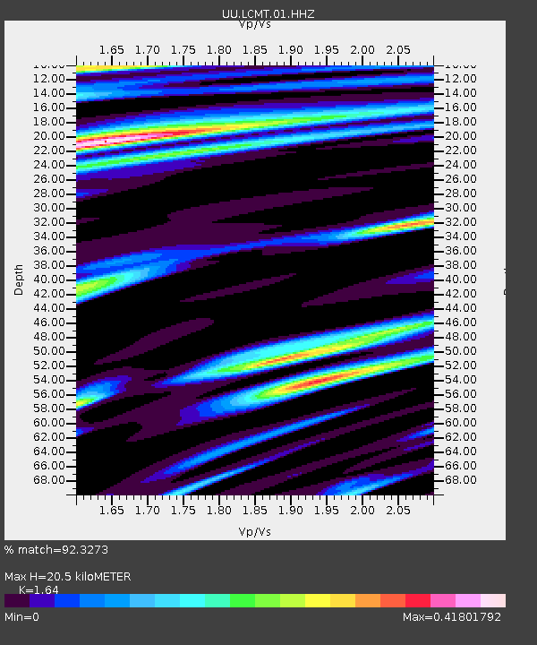
| Estimated Moho Depth: |
20.5 km |
| Estimated Crust Vp/Vs: |
1.64 |
| Assumed Crust Vp: |
6.194 km/s |
| Estimated Crust Vs: |
3.777 km/s |
| Estimated Crust Poisson's Ratio: |
0.20 |
|
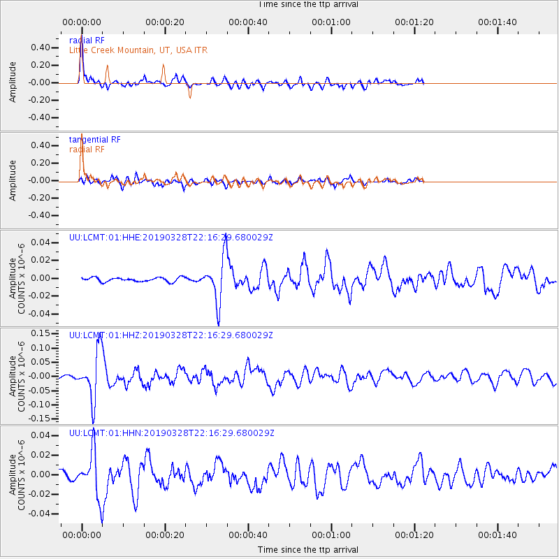
| Radial Match: |
92.3273 % |
| Radial Bump: |
390 |
| Transverse Match: |
78.80176 % |
| Transverse Bump: |
400 |
| SOD ConfigId: |
3426611 |
| Insert Time: |
2019-04-11 22:28:25.959 +0000 |
| GWidth: |
2.5 |
| Max Bumps: |
400 |
| Tol: |
0.001 |
|
Signal To Noise
| Channel | StoN | STA | LTA |
| UU:LCMT:01:HHZ:20190328T22:16:29.680029Z | 17.464256 | 8.628682E-8 | 4.940767E-9 |
| UU:LCMT:01:HHN:20190328T22:16:29.680029Z | 4.3639297 | 2.3148393E-8 | 5.304484E-9 |
| UU:LCMT:01:HHE:20190328T22:16:29.680029Z | 11.111637 | 2.5614193E-8 | 2.305168E-9 |
| Arrivals |
| Ps | 2.2 SECOND |
| PpPs | 8.3 SECOND |
| PsPs/PpSs | 11 SECOND |


