You are here: Home > Network List > UU - University of Utah Regional Network Stations List
> Station WPUT Wasatch Plateau, UT,USA > Earthquake Result Viewer
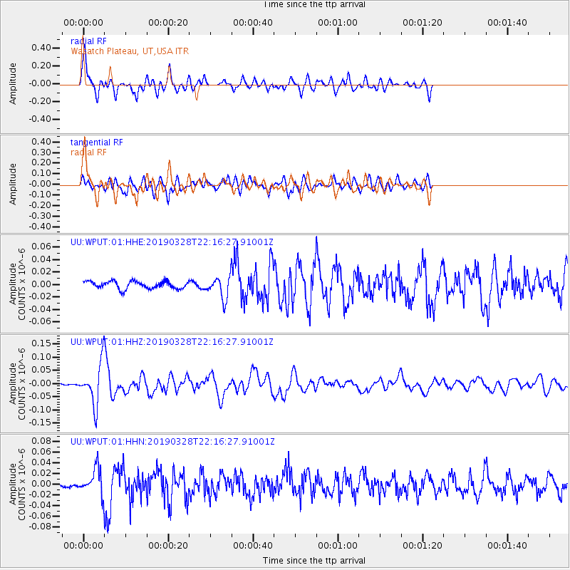
WPUT Wasatch Plateau, UT,USA - Earthquake Result Viewer

| Earthquake location: |
East Of Kuril Islands |
| Earthquake latitude/longitude: |
50.5/160.0 |
| Earthquake time(UTC): |
2019/03/28 (087) 22:06:49 GMT |
| Earthquake Depth: |
9.0 km |
| Earthquake Magnitude: |
6.2 Mww |
| Earthquake Catalog/Contributor: |
NEIC PDE/us |
|
| Network: |
UU University of Utah Regional Network |
| Station: |
WPUT Wasatch Plateau, UT,USA |
| Lat/Lon: |
39.00 N/111.36 W |
| Elevation: |
2618 m |
|
| Distance: |
60.4 deg |
| Az: |
63.619 deg |
| Baz: |
312.763 deg |
| Ray Param: |
0.061552946 |
| Estimated Moho Depth: |
50.75 km |
| Estimated Crust Vp/Vs: |
1.63 |
| Assumed Crust Vp: |
6.207 km/s |
| Estimated Crust Vs: |
3.796 km/s |
| Estimated Crust Poisson's Ratio: |
0.20 |
|
| Radial Match: |
83.07028 % |
| Radial Bump: |
400 |
| Transverse Match: |
58.270664 % |
| Transverse Bump: |
400 |
| SOD ConfigId: |
3426611 |
| Insert Time: |
2019-04-11 22:28:54.181 +0000 |
| GWidth: |
2.5 |
| Max Bumps: |
400 |
| Tol: |
0.001 |
|
Signal To Noise
| Channel | StoN | STA | LTA |
| UU:WPUT:01:HHZ:20190328T22:16:27.91001Z | 18.614075 | 7.86317E-8 | 4.2243142E-9 |
| UU:WPUT:01:HHN:20190328T22:16:27.91001Z | 4.9045186 | 2.3962654E-8 | 4.885832E-9 |
| UU:WPUT:01:HHE:20190328T22:16:27.91001Z | 3.0340304 | 1.8093573E-8 | 5.9635434E-9 |
| Arrivals |
| Ps | 5.4 SECOND |
| PpPs | 21 SECOND |
| PsPs/PpSs | 26 SECOND |


