You are here: Home > Network List > CI - Caltech Regional Seismic Network Stations List
> Station LRL Laurel Mtn Radio Fac, Ridgecrest, CA, USA > Earthquake Result Viewer
LRL Laurel Mtn Radio Fac, Ridgecrest, CA, USA - Earthquake Result Viewer
| Earthquake location: |
South Of Panama |
| Earthquake latitude/longitude: |
5.3/-82.6 |
| Earthquake time(UTC): |
2012/06/04 (156) 00:45:15 GMT |
| Earthquake Depth: |
7.0 km |
| Earthquake Magnitude: |
5.9 MB, 5.9 MS, 6.3 MW, 6.2 MW |
| Earthquake Catalog/Contributor: |
WHDF/NEIC |
|
| Network: |
CI Caltech Regional Seismic Network |
| Station: |
LRL Laurel Mtn Radio Fac, Ridgecrest, CA, USA |
| Lat/Lon: |
35.48 N/117.68 W |
| Elevation: |
1340 m |
|
| Distance: |
44.1 deg |
| Az: |
317.638 deg |
| Baz: |
124.704 deg |
| Ray Param: |
0.07214463 |
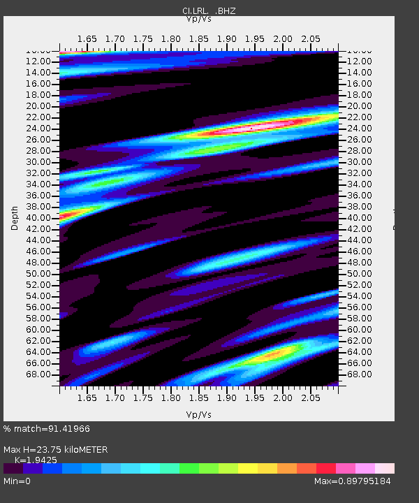
| Estimated Moho Depth: |
23.75 km |
| Estimated Crust Vp/Vs: |
1.94 |
| Assumed Crust Vp: |
6.276 km/s |
| Estimated Crust Vs: |
3.231 km/s |
| Estimated Crust Poisson's Ratio: |
0.32 |
|
| Radial Match: |
91.41966 % |
| Radial Bump: |
376 |
| Transverse Match: |
64.94981 % |
| Transverse Bump: |
400 |
| SOD ConfigId: |
458385 |
| Insert Time: |
2012-10-16 08:04:43.030 +0000 |
| GWidth: |
2.5 |
| Max Bumps: |
400 |
| Tol: |
0.001 |
|

Signal To Noise
| Channel | StoN | STA | LTA |
| CI:LRL: :BHZ:20120604T00:52:52.969993Z | 5.963531 | 1.3029862E-6 | 2.184924E-7 |
| CI:LRL: :BHN:20120604T00:52:52.969993Z | 2.613069 | 4.773918E-7 | 1.826939E-7 |
| CI:LRL: :BHE:20120604T00:52:52.969993Z | 2.6601393 | 5.0054035E-7 | 1.881632E-7 |
| Arrivals |
| Ps | 3.8 SECOND |
| PpPs | 11 SECOND |
| PsPs/PpSs | 14 SECOND |


