You are here: Home > Network List > IU - Global Seismograph Network (GSN - IRIS/USGS) Stations List
> Station POHA Pohakuloa, Hawaii, USA > Earthquake Result Viewer
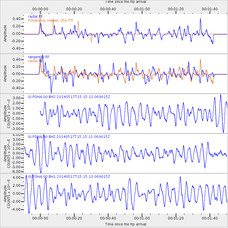
POHA Pohakuloa, Hawaii, USA - Earthquake Result Viewer
*The percent match for this event was below the threshold and hence no stack was calculated.
| Earthquake location: |
Tonga Islands |
| Earthquake latitude/longitude: |
-16.6/-175.2 |
| Earthquake time(UTC): |
2014/05/17 (137) 15:08:00 GMT |
| Earthquake Depth: |
10 km |
| Earthquake Magnitude: |
4.4 mb |
| Earthquake Catalog/Contributor: |
ISC/ISC |
|
| Network: |
IU Global Seismograph Network (GSN - IRIS/USGS) |
| Station: |
POHA Pohakuloa, Hawaii, USA |
| Lat/Lon: |
19.76 N/155.53 W |
| Elevation: |
1990 m |
|
| Distance: |
41.0 deg |
| Az: |
28.904 deg |
| Baz: |
209.468 deg |
| Ray Param: |
$rayparam |
*The percent match for this event was below the threshold and hence was not used in the summary stack. |
|
| Radial Match: |
62.773006 % |
| Radial Bump: |
400 |
| Transverse Match: |
67.485 % |
| Transverse Bump: |
400 |
| SOD ConfigId: |
3390531 |
| Insert Time: |
2019-04-11 22:32:19.163 +0000 |
| GWidth: |
2.5 |
| Max Bumps: |
400 |
| Tol: |
0.001 |
|
Signal To Noise
| Channel | StoN | STA | LTA |
| IU:POHA:00:BHZ:20140517T15:15:13.069015Z | 1.8521715 | 2.6583868E-6 | 1.4352811E-6 |
| IU:POHA:00:BH1:20140517T15:15:13.069015Z | 1.3654455 | 2.4664353E-6 | 1.8063226E-6 |
| IU:POHA:00:BH2:20140517T15:15:13.069015Z | 0.9396318 | 8.5944146E-7 | 9.146577E-7 |
| Arrivals |
| Ps | |
| PpPs | |
| PsPs/PpSs | |


