You are here: Home > Network List > TA - USArray Transportable Network (new EarthScope stations) Stations List
> Station J04D Umpqua National Forest, Toketee, OR, USA > Earthquake Result Viewer
J04D Umpqua National Forest, Toketee, OR, USA - Earthquake Result Viewer
| Earthquake location: |
South Of Panama |
| Earthquake latitude/longitude: |
5.3/-82.6 |
| Earthquake time(UTC): |
2012/06/04 (156) 00:45:15 GMT |
| Earthquake Depth: |
7.0 km |
| Earthquake Magnitude: |
5.9 MB, 5.9 MS, 6.3 MW, 6.2 MW |
| Earthquake Catalog/Contributor: |
WHDF/NEIC |
|
| Network: |
TA USArray Transportable Network (new EarthScope stations) |
| Station: |
J04D Umpqua National Forest, Toketee, OR, USA |
| Lat/Lon: |
43.24 N/122.11 W |
| Elevation: |
1948 m |
|
| Distance: |
51.4 deg |
| Az: |
323.5 deg |
| Baz: |
125.854 deg |
| Ray Param: |
0.06746727 |
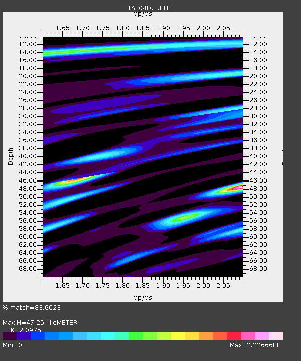
| Estimated Moho Depth: |
47.25 km |
| Estimated Crust Vp/Vs: |
2.10 |
| Assumed Crust Vp: |
6.522 km/s |
| Estimated Crust Vs: |
3.109 km/s |
| Estimated Crust Poisson's Ratio: |
0.35 |
|
| Radial Match: |
83.6023 % |
| Radial Bump: |
400 |
| Transverse Match: |
76.87844 % |
| Transverse Bump: |
400 |
| SOD ConfigId: |
458385 |
| Insert Time: |
2012-10-16 08:17:32.048 +0000 |
| GWidth: |
2.5 |
| Max Bumps: |
400 |
| Tol: |
0.001 |
|
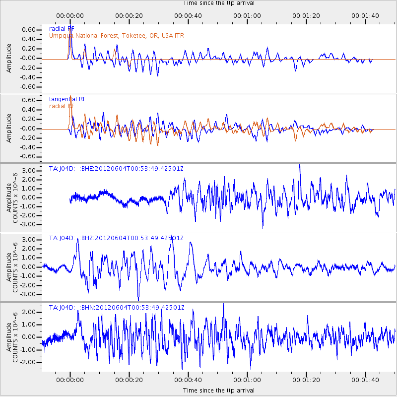
Signal To Noise
| Channel | StoN | STA | LTA |
| TA:J04D: :BHZ:20120604T00:53:49.42501Z | 5.672955 | 1.2567422E-6 | 2.2153219E-7 |
| TA:J04D: :BHN:20120604T00:53:49.42501Z | 2.3083582 | 8.424124E-7 | 3.6494006E-7 |
| TA:J04D: :BHE:20120604T00:53:49.42501Z | 1.4748895 | 5.905675E-7 | 4.0041473E-7 |
| Arrivals |
| Ps | 8.4 SECOND |
| PpPs | 21 SECOND |
| PsPs/PpSs | 30 SECOND |


