You are here: Home > Network List > TA - USArray Transportable Network (new EarthScope stations) Stations List
> Station J05D Fort Rock, OR, USA > Earthquake Result Viewer
J05D Fort Rock, OR, USA - Earthquake Result Viewer
| Earthquake location: |
South Of Panama |
| Earthquake latitude/longitude: |
5.3/-82.6 |
| Earthquake time(UTC): |
2012/06/04 (156) 00:45:15 GMT |
| Earthquake Depth: |
7.0 km |
| Earthquake Magnitude: |
5.9 MB, 5.9 MS, 6.3 MW, 6.2 MW |
| Earthquake Catalog/Contributor: |
WHDF/NEIC |
|
| Network: |
TA USArray Transportable Network (new EarthScope stations) |
| Station: |
J05D Fort Rock, OR, USA |
| Lat/Lon: |
43.28 N/121.23 W |
| Elevation: |
1541 m |
|
| Distance: |
50.9 deg |
| Az: |
324.032 deg |
| Baz: |
126.785 deg |
| Ray Param: |
0.06777192 |
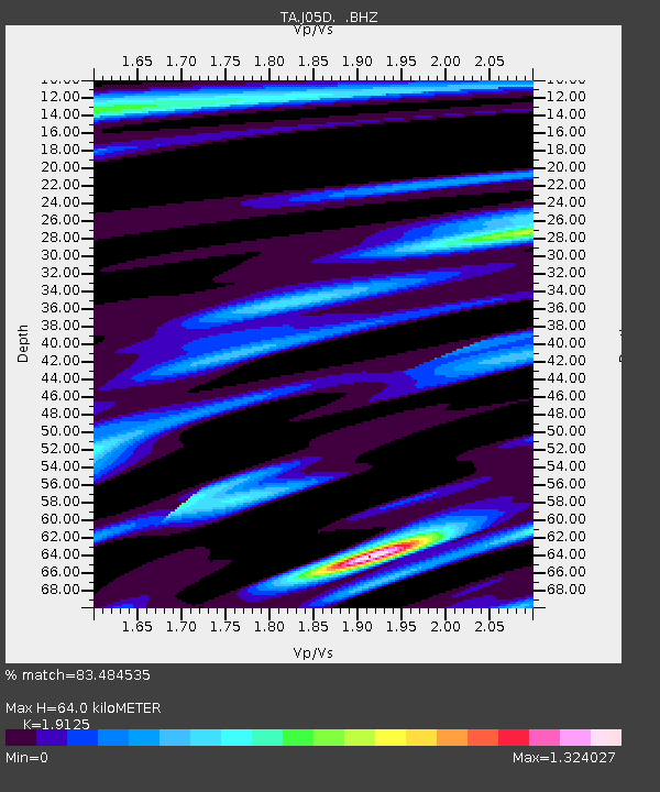
| Estimated Moho Depth: |
64.0 km |
| Estimated Crust Vp/Vs: |
1.91 |
| Assumed Crust Vp: |
6.597 km/s |
| Estimated Crust Vs: |
3.45 km/s |
| Estimated Crust Poisson's Ratio: |
0.31 |
|
| Radial Match: |
83.484535 % |
| Radial Bump: |
400 |
| Transverse Match: |
79.48784 % |
| Transverse Bump: |
400 |
| SOD ConfigId: |
458385 |
| Insert Time: |
2012-10-16 08:17:44.002 +0000 |
| GWidth: |
2.5 |
| Max Bumps: |
400 |
| Tol: |
0.001 |
|
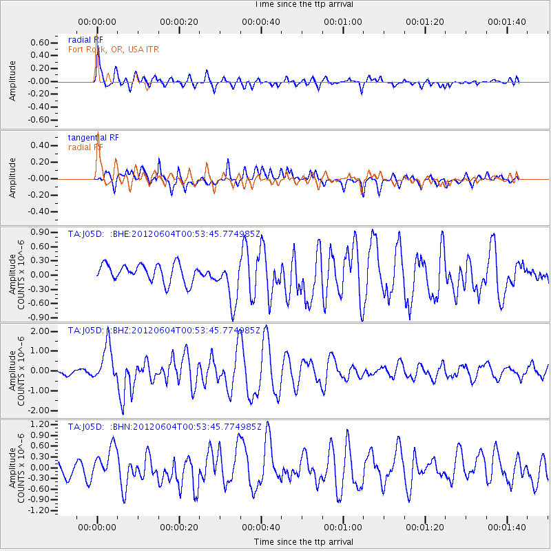
Signal To Noise
| Channel | StoN | STA | LTA |
| TA:J05D: :BHZ:20120604T00:53:45.774985Z | 5.184159 | 9.623274E-7 | 1.8562845E-7 |
| TA:J05D: :BHN:20120604T00:53:45.774985Z | 2.141721 | 4.37882E-7 | 2.0445333E-7 |
| TA:J05D: :BHE:20120604T00:53:45.774985Z | 2.5367608 | 4.7589492E-7 | 1.8759945E-7 |
| Arrivals |
| Ps | 9.4 SECOND |
| PpPs | 27 SECOND |
| PsPs/PpSs | 36 SECOND |


