You are here: Home > Network List > TA - USArray Transportable Network (new EarthScope stations) Stations List
> Station I31A Royce, Wessington Springs, SD, USA > Earthquake Result Viewer
I31A Royce, Wessington Springs, SD, USA - Earthquake Result Viewer
| Earthquake location: |
South Of Panama |
| Earthquake latitude/longitude: |
5.3/-82.6 |
| Earthquake time(UTC): |
2012/06/04 (156) 00:45:15 GMT |
| Earthquake Depth: |
7.0 km |
| Earthquake Magnitude: |
5.9 MB, 5.9 MS, 6.3 MW, 6.2 MW |
| Earthquake Catalog/Contributor: |
WHDF/NEIC |
|
| Network: |
TA USArray Transportable Network (new EarthScope stations) |
| Station: |
I31A Royce, Wessington Springs, SD, USA |
| Lat/Lon: |
44.03 N/98.54 W |
| Elevation: |
469 m |
|
| Distance: |
41.0 deg |
| Az: |
342.474 deg |
| Baz: |
155.435 deg |
| Ray Param: |
0.07405495 |
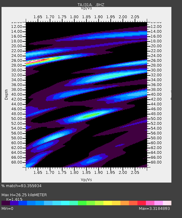
| Estimated Moho Depth: |
26.25 km |
| Estimated Crust Vp/Vs: |
1.62 |
| Assumed Crust Vp: |
6.53 km/s |
| Estimated Crust Vs: |
4.044 km/s |
| Estimated Crust Poisson's Ratio: |
0.19 |
|
| Radial Match: |
93.355934 % |
| Radial Bump: |
248 |
| Transverse Match: |
68.62735 % |
| Transverse Bump: |
399 |
| SOD ConfigId: |
458385 |
| Insert Time: |
2012-10-16 08:18:40.030 +0000 |
| GWidth: |
2.5 |
| Max Bumps: |
400 |
| Tol: |
0.001 |
|

Signal To Noise
| Channel | StoN | STA | LTA |
| TA:I31A: :BHZ:20120604T00:52:28.224998Z | 8.140745 | 1.5548231E-6 | 1.9099272E-7 |
| TA:I31A: :BHN:20120604T00:52:28.224998Z | 4.4318857 | 1.2105636E-6 | 2.7314866E-7 |
| TA:I31A: :BHE:20120604T00:52:28.224998Z | 3.4408247 | 7.6649985E-7 | 2.2276632E-7 |
| Arrivals |
| Ps | 2.7 SECOND |
| PpPs | 9.7 SECOND |
| PsPs/PpSs | 12 SECOND |


