You are here: Home > Network List > TA - USArray Transportable Network (new EarthScope stations) Stations List
> Station D34A Park Rapids, MN, USA > Earthquake Result Viewer
D34A Park Rapids, MN, USA - Earthquake Result Viewer

| Earthquake location: |
South Of Panama |
| Earthquake latitude/longitude: |
5.3/-82.6 |
| Earthquake time(UTC): |
2012/06/04 (156) 00:45:15 GMT |
| Earthquake Depth: |
7.0 km |
| Earthquake Magnitude: |
5.9 MB, 5.9 MS, 6.3 MW, 6.2 MW |
| Earthquake Catalog/Contributor: |
WHDF/NEIC |
|
| Network: |
TA USArray Transportable Network (new EarthScope stations) |
| Station: |
D34A Park Rapids, MN, USA |
| Lat/Lon: |
47.09 N/95.20 W |
| Elevation: |
476 m |
|
| Distance: |
43.0 deg |
| Az: |
347.411 deg |
| Baz: |
161.482 deg |
| Ray Param: |
0.07283362 |
| Estimated Moho Depth: |
35.75 km |
| Estimated Crust Vp/Vs: |
1.90 |
| Assumed Crust Vp: |
6.419 km/s |
| Estimated Crust Vs: |
3.37 km/s |
| Estimated Crust Poisson's Ratio: |
0.31 |
|
| Radial Match: |
85.681816 % |
| Radial Bump: |
400 |
| Transverse Match: |
56.738148 % |
| Transverse Bump: |
400 |
| SOD ConfigId: |
458385 |
| Insert Time: |
2012-10-16 08:20:47.707 +0000 |
| GWidth: |
2.5 |
| Max Bumps: |
400 |
| Tol: |
0.001 |
|
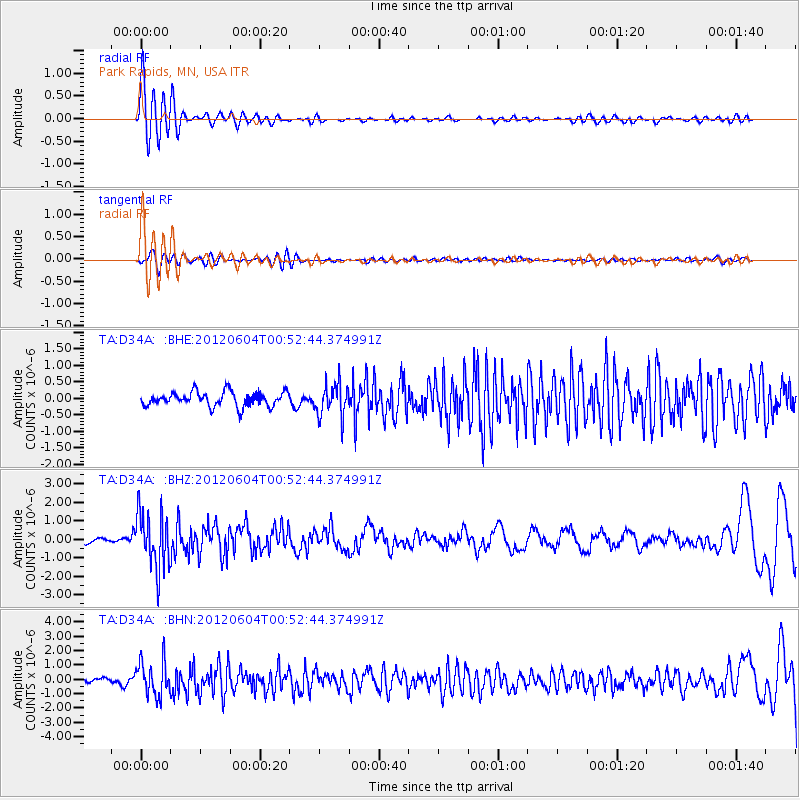
Signal To Noise
| Channel | StoN | STA | LTA |
| TA:D34A: :BHZ:20120604T00:52:44.374991Z | 11.652456 | 1.524418E-6 | 1.3082376E-7 |
| TA:D34A: :BHN:20120604T00:52:44.374991Z | 5.4280596 | 1.2141153E-6 | 2.2367392E-7 |
| TA:D34A: :BHE:20120604T00:52:44.374991Z | 2.2702112 | 4.9265583E-7 | 2.1700882E-7 |
| Arrivals |
| Ps | 5.4 SECOND |
| PpPs | 15 SECOND |
| PsPs/PpSs | 21 SECOND |


