You are here: Home > Network List > TA - USArray Transportable Network (new EarthScope stations) Stations List
> Station C35A Jirik Farms, Max, MN, USA > Earthquake Result Viewer
C35A Jirik Farms, Max, MN, USA - Earthquake Result Viewer

| Earthquake location: |
South Of Panama |
| Earthquake latitude/longitude: |
5.3/-82.6 |
| Earthquake time(UTC): |
2012/06/04 (156) 00:45:15 GMT |
| Earthquake Depth: |
7.0 km |
| Earthquake Magnitude: |
5.9 MB, 5.9 MS, 6.3 MW, 6.2 MW |
| Earthquake Catalog/Contributor: |
WHDF/NEIC |
|
| Network: |
TA USArray Transportable Network (new EarthScope stations) |
| Station: |
C35A Jirik Farms, Max, MN, USA |
| Lat/Lon: |
47.70 N/93.98 W |
| Elevation: |
426 m |
|
| Distance: |
43.3 deg |
| Az: |
348.836 deg |
| Baz: |
163.416 deg |
| Ray Param: |
0.07261826 |
| Estimated Moho Depth: |
23.25 km |
| Estimated Crust Vp/Vs: |
1.79 |
| Assumed Crust Vp: |
6.571 km/s |
| Estimated Crust Vs: |
3.671 km/s |
| Estimated Crust Poisson's Ratio: |
0.27 |
|
| Radial Match: |
92.076385 % |
| Radial Bump: |
191 |
| Transverse Match: |
59.775524 % |
| Transverse Bump: |
400 |
| SOD ConfigId: |
458385 |
| Insert Time: |
2012-10-16 08:22:04.179 +0000 |
| GWidth: |
2.5 |
| Max Bumps: |
400 |
| Tol: |
0.001 |
|
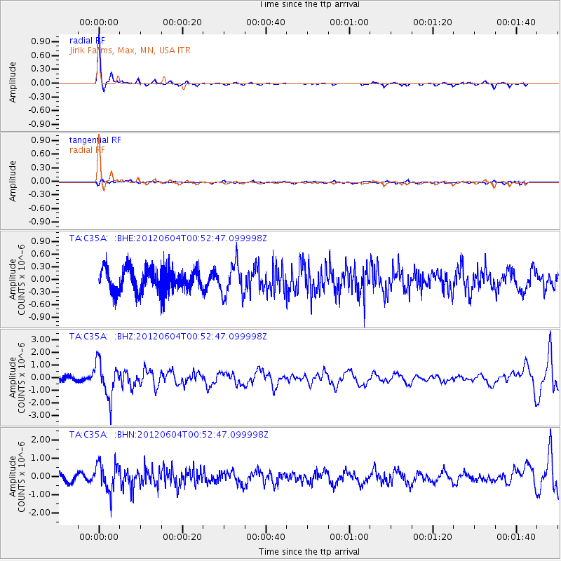
Signal To Noise
| Channel | StoN | STA | LTA |
| TA:C35A: :BHZ:20120604T00:52:47.099998Z | 6.095089 | 1.423892E-6 | 2.33613E-7 |
| TA:C35A: :BHN:20120604T00:52:47.099998Z | 4.227846 | 7.880982E-7 | 1.8640655E-7 |
| TA:C35A: :BHE:20120604T00:52:47.099998Z | 1.4447376 | 3.8354077E-7 | 2.6547437E-7 |
| Arrivals |
| Ps | 3.0 SECOND |
| PpPs | 9.2 SECOND |
| PsPs/PpSs | 12 SECOND |


