You are here: Home > Network List > TA - USArray Transportable Network (new EarthScope stations) Stations List
> Station A32A Rocking H Ranch, Lancaster, MN, USA > Earthquake Result Viewer
A32A Rocking H Ranch, Lancaster, MN, USA - Earthquake Result Viewer

| Earthquake location: |
South Of Panama |
| Earthquake latitude/longitude: |
5.3/-82.6 |
| Earthquake time(UTC): |
2012/06/04 (156) 00:45:15 GMT |
| Earthquake Depth: |
7.0 km |
| Earthquake Magnitude: |
5.9 MB, 5.9 MS, 6.3 MW, 6.2 MW |
| Earthquake Catalog/Contributor: |
WHDF/NEIC |
|
| Network: |
TA USArray Transportable Network (new EarthScope stations) |
| Station: |
A32A Rocking H Ranch, Lancaster, MN, USA |
| Lat/Lon: |
48.92 N/96.49 W |
| Elevation: |
322 m |
|
| Distance: |
45.0 deg |
| Az: |
347.089 deg |
| Baz: |
160.289 deg |
| Ray Param: |
0.07155661 |
| Estimated Moho Depth: |
47.25 km |
| Estimated Crust Vp/Vs: |
1.66 |
| Assumed Crust Vp: |
6.498 km/s |
| Estimated Crust Vs: |
3.902 km/s |
| Estimated Crust Poisson's Ratio: |
0.22 |
|
| Radial Match: |
85.296585 % |
| Radial Bump: |
233 |
| Transverse Match: |
56.648067 % |
| Transverse Bump: |
400 |
| SOD ConfigId: |
458385 |
| Insert Time: |
2012-10-16 08:24:12.956 +0000 |
| GWidth: |
2.5 |
| Max Bumps: |
400 |
| Tol: |
0.001 |
|
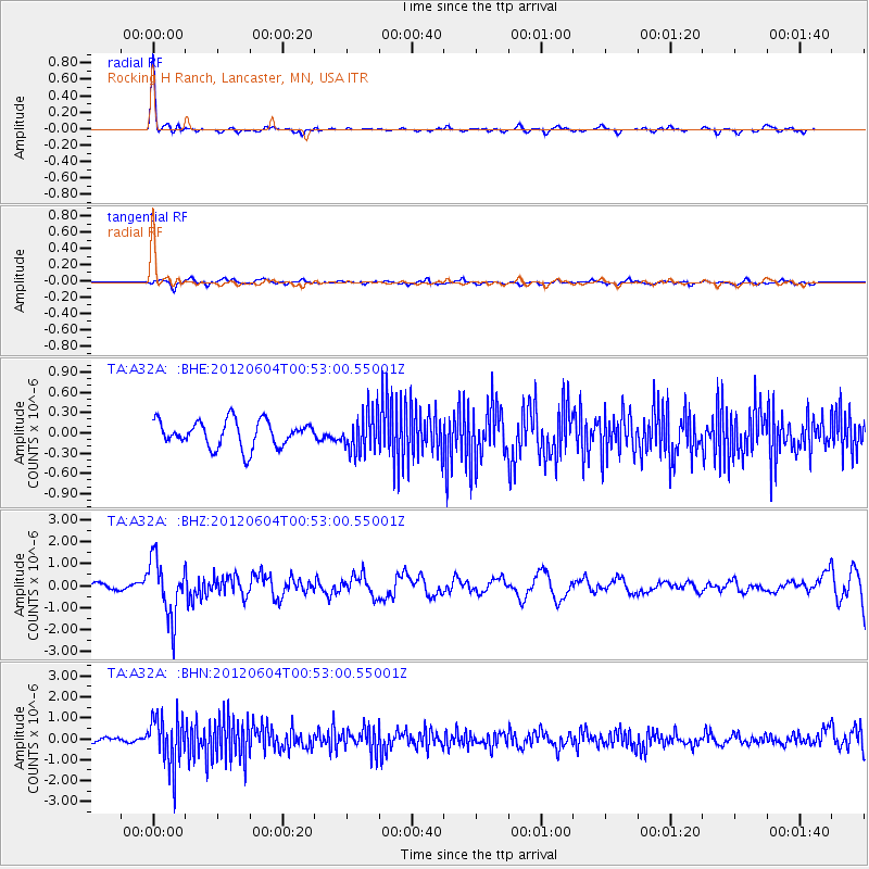
Signal To Noise
| Channel | StoN | STA | LTA |
| TA:A32A: :BHZ:20120604T00:53:00.55001Z | 5.001255 | 1.3124368E-6 | 2.6242148E-7 |
| TA:A32A: :BHN:20120604T00:53:00.55001Z | 10.335404 | 1.1832093E-6 | 1.1448118E-7 |
| TA:A32A: :BHE:20120604T00:53:00.55001Z | 1.4766777 | 2.853961E-7 | 1.9326907E-7 |
| Arrivals |
| Ps | 5.2 SECOND |
| PpPs | 18 SECOND |
| PsPs/PpSs | 23 SECOND |


