You are here: Home > Network List > TA - USArray Transportable Network (new EarthScope stations) Stations List
> Station L37A Phoenix Point, Boone, IA, USA > Earthquake Result Viewer
L37A Phoenix Point, Boone, IA, USA - Earthquake Result Viewer
| Earthquake location: |
South Of Panama |
| Earthquake latitude/longitude: |
5.3/-82.6 |
| Earthquake time(UTC): |
2012/06/04 (156) 00:45:15 GMT |
| Earthquake Depth: |
7.0 km |
| Earthquake Magnitude: |
5.9 MB, 5.9 MS, 6.3 MW, 6.2 MW |
| Earthquake Catalog/Contributor: |
WHDF/NEIC |
|
| Network: |
TA USArray Transportable Network (new EarthScope stations) |
| Station: |
L37A Phoenix Point, Boone, IA, USA |
| Lat/Lon: |
42.12 N/93.75 W |
| Elevation: |
312 m |
|
| Distance: |
38.0 deg |
| Az: |
346.51 deg |
| Baz: |
161.806 deg |
| Ray Param: |
0.075834855 |
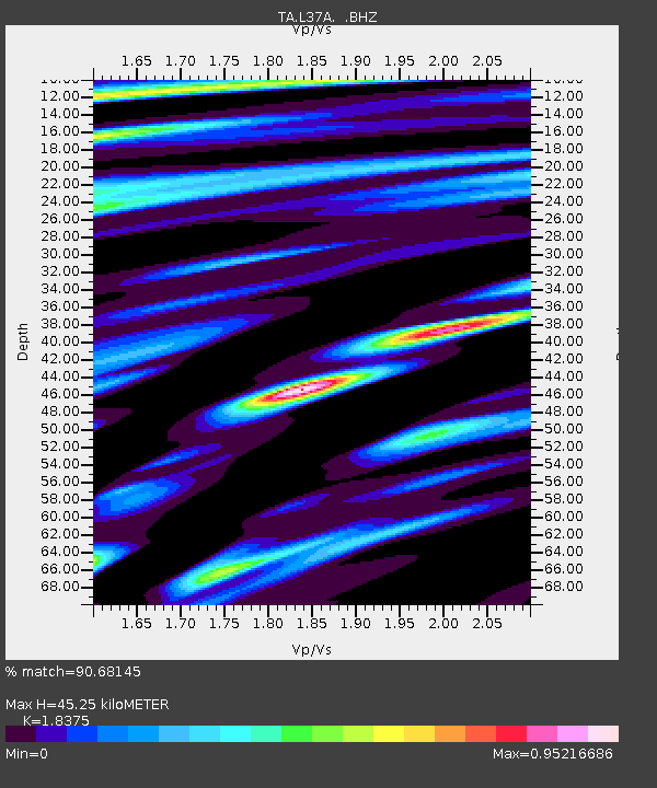
| Estimated Moho Depth: |
45.25 km |
| Estimated Crust Vp/Vs: |
1.84 |
| Assumed Crust Vp: |
6.53 km/s |
| Estimated Crust Vs: |
3.554 km/s |
| Estimated Crust Poisson's Ratio: |
0.29 |
|
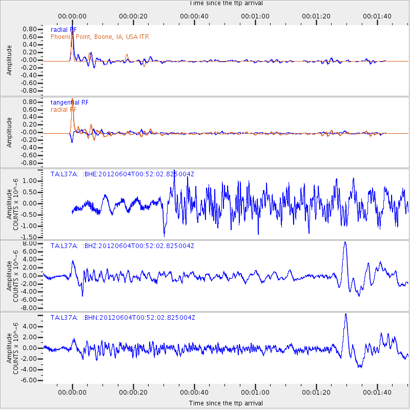
| Radial Match: |
90.68145 % |
| Radial Bump: |
400 |
| Transverse Match: |
70.210754 % |
| Transverse Bump: |
400 |
| SOD ConfigId: |
458385 |
| Insert Time: |
2012-10-16 08:25:10.145 +0000 |
| GWidth: |
2.5 |
| Max Bumps: |
400 |
| Tol: |
0.001 |
|
Signal To Noise
| Channel | StoN | STA | LTA |
| TA:L37A: :BHZ:20120604T00:52:02.825004Z | 6.2052627 | 2.10162E-6 | 3.3868352E-7 |
| TA:L37A: :BHN:20120604T00:52:02.825004Z | 3.8098624 | 9.468E-7 | 2.4851292E-7 |
| TA:L37A: :BHE:20120604T00:52:02.825004Z | 3.3555965 | 6.498655E-7 | 1.9366617E-7 |
| Arrivals |
| Ps | 6.2 SECOND |
| PpPs | 18 SECOND |
| PsPs/PpSs | 25 SECOND |


