You are here: Home > Network List > TA - USArray Transportable Network (new EarthScope stations) Stations List
> Station O38A Galt, MO, USA > Earthquake Result Viewer
O38A Galt, MO, USA - Earthquake Result Viewer
| Earthquake location: |
South Of Panama |
| Earthquake latitude/longitude: |
5.3/-82.6 |
| Earthquake time(UTC): |
2012/06/04 (156) 00:45:15 GMT |
| Earthquake Depth: |
7.0 km |
| Earthquake Magnitude: |
5.9 MB, 5.9 MS, 6.3 MW, 6.2 MW |
| Earthquake Catalog/Contributor: |
WHDF/NEIC |
|
| Network: |
TA USArray Transportable Network (new EarthScope stations) |
| Station: |
O38A Galt, MO, USA |
| Lat/Lon: |
40.12 N/93.47 W |
| Elevation: |
266 m |
|
| Distance: |
36.0 deg |
| Az: |
345.797 deg |
| Baz: |
161.42 deg |
| Ray Param: |
0.07691949 |
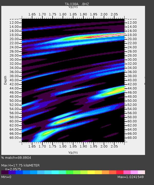
| Estimated Moho Depth: |
17.75 km |
| Estimated Crust Vp/Vs: |
2.06 |
| Assumed Crust Vp: |
6.498 km/s |
| Estimated Crust Vs: |
3.158 km/s |
| Estimated Crust Poisson's Ratio: |
0.35 |
|
| Radial Match: |
89.8904 % |
| Radial Bump: |
400 |
| Transverse Match: |
54.74849 % |
| Transverse Bump: |
400 |
| SOD ConfigId: |
458385 |
| Insert Time: |
2012-10-16 08:25:34.586 +0000 |
| GWidth: |
2.5 |
| Max Bumps: |
400 |
| Tol: |
0.001 |
|
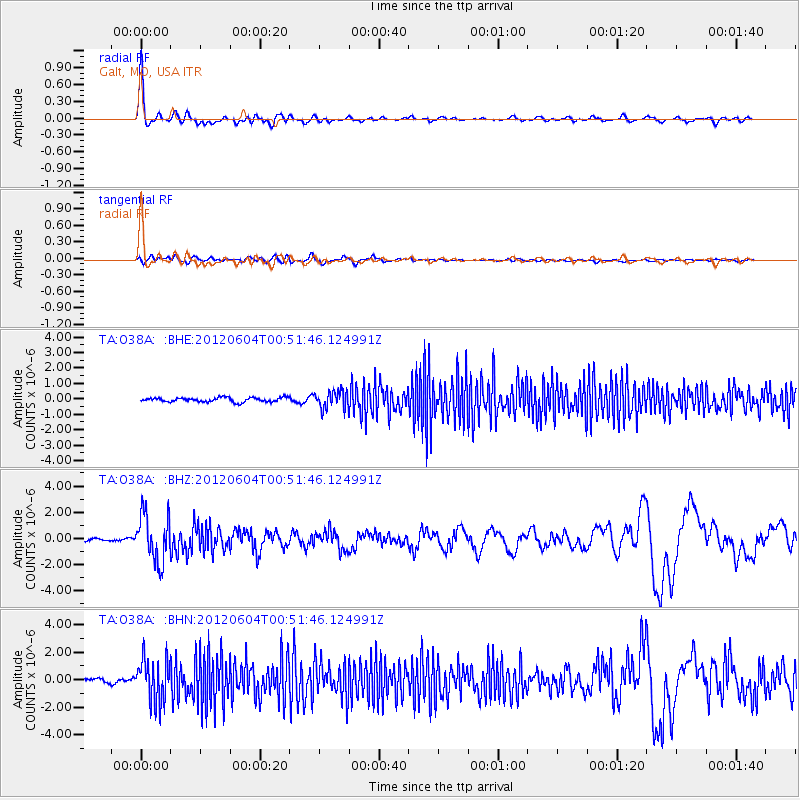
Signal To Noise
| Channel | StoN | STA | LTA |
| TA:O38A: :BHZ:20120604T00:51:46.124991Z | 10.383828 | 1.8219606E-6 | 1.7546135E-7 |
| TA:O38A: :BHN:20120604T00:51:46.124991Z | 8.936208 | 1.5630887E-6 | 1.7491634E-7 |
| TA:O38A: :BHE:20120604T00:51:46.124991Z | 4.049343 | 5.734382E-7 | 1.4161265E-7 |
| Arrivals |
| Ps | 3.1 SECOND |
| PpPs | 7.8 SECOND |
| PsPs/PpSs | 11 SECOND |


