You are here: Home > Network List > TA - USArray Transportable Network (new EarthScope stations) Stations List
> Station O40A La Belle, MO, USA > Earthquake Result Viewer
O40A La Belle, MO, USA - Earthquake Result Viewer
| Earthquake location: |
South Of Panama |
| Earthquake latitude/longitude: |
5.3/-82.6 |
| Earthquake time(UTC): |
2012/06/04 (156) 00:45:15 GMT |
| Earthquake Depth: |
7.0 km |
| Earthquake Magnitude: |
5.9 MB, 5.9 MS, 6.3 MW, 6.2 MW |
| Earthquake Catalog/Contributor: |
WHDF/NEIC |
|
| Network: |
TA USArray Transportable Network (new EarthScope stations) |
| Station: |
O40A La Belle, MO, USA |
| Lat/Lon: |
40.12 N/91.87 W |
| Elevation: |
206 m |
|
| Distance: |
35.6 deg |
| Az: |
347.797 deg |
| Baz: |
164.068 deg |
| Ray Param: |
0.077117085 |
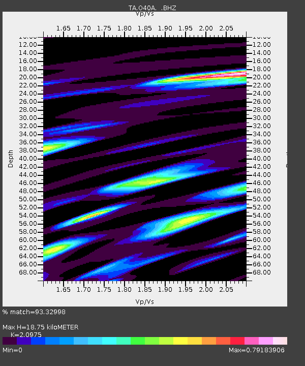
| Estimated Moho Depth: |
18.75 km |
| Estimated Crust Vp/Vs: |
2.10 |
| Assumed Crust Vp: |
6.498 km/s |
| Estimated Crust Vs: |
3.098 km/s |
| Estimated Crust Poisson's Ratio: |
0.35 |
|
| Radial Match: |
93.32998 % |
| Radial Bump: |
306 |
| Transverse Match: |
59.95552 % |
| Transverse Bump: |
400 |
| SOD ConfigId: |
458385 |
| Insert Time: |
2012-10-16 08:26:34.636 +0000 |
| GWidth: |
2.5 |
| Max Bumps: |
400 |
| Tol: |
0.001 |
|

Signal To Noise
| Channel | StoN | STA | LTA |
| TA:O40A: :BHZ:20120604T00:51:43.024985Z | 7.511148 | 1.8740869E-6 | 2.495074E-7 |
| TA:O40A: :BHN:20120604T00:51:43.024985Z | 8.663764 | 1.1359399E-6 | 1.311139E-7 |
| TA:O40A: :BHE:20120604T00:51:43.024985Z | 2.393256 | 4.8320163E-7 | 2.0190134E-7 |
| Arrivals |
| Ps | 3.4 SECOND |
| PpPs | 8.4 SECOND |
| PsPs/PpSs | 12 SECOND |


