You are here: Home > Network List > TA - USArray Transportable Network (new EarthScope stations) Stations List
> Station X40A Basin Creek Farm, Marlvern, AR, USA > Earthquake Result Viewer
X40A Basin Creek Farm, Marlvern, AR, USA - Earthquake Result Viewer
| Earthquake location: |
South Of Panama |
| Earthquake latitude/longitude: |
5.3/-82.6 |
| Earthquake time(UTC): |
2012/06/04 (156) 00:45:15 GMT |
| Earthquake Depth: |
7.0 km |
| Earthquake Magnitude: |
5.9 MB, 5.9 MS, 6.3 MW, 6.2 MW |
| Earthquake Catalog/Contributor: |
WHDF/NEIC |
|
| Network: |
TA USArray Transportable Network (new EarthScope stations) |
| Station: |
X40A Basin Creek Farm, Marlvern, AR, USA |
| Lat/Lon: |
34.49 N/92.83 W |
| Elevation: |
158 m |
|
| Distance: |
30.5 deg |
| Az: |
343.261 deg |
| Baz: |
159.683 deg |
| Ray Param: |
0.07930921 |
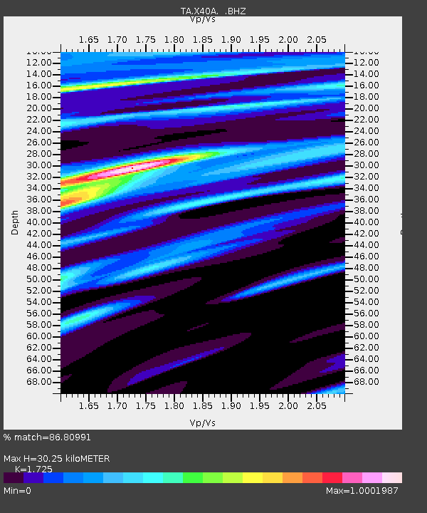
| Estimated Moho Depth: |
30.25 km |
| Estimated Crust Vp/Vs: |
1.73 |
| Assumed Crust Vp: |
6.498 km/s |
| Estimated Crust Vs: |
3.767 km/s |
| Estimated Crust Poisson's Ratio: |
0.25 |
|
| Radial Match: |
86.80991 % |
| Radial Bump: |
400 |
| Transverse Match: |
73.63629 % |
| Transverse Bump: |
400 |
| SOD ConfigId: |
458385 |
| Insert Time: |
2012-10-16 08:26:58.134 +0000 |
| GWidth: |
2.5 |
| Max Bumps: |
400 |
| Tol: |
0.001 |
|

Signal To Noise
| Channel | StoN | STA | LTA |
| TA:X40A: :BHZ:20120604T00:50:58.55001Z | 13.264645 | 1.3965636E-6 | 1.05284656E-7 |
| TA:X40A: :BHN:20120604T00:50:58.55001Z | 4.1492295 | 5.514458E-7 | 1.3290318E-7 |
| TA:X40A: :BHE:20120604T00:50:58.55001Z | 4.8135495 | 4.3387246E-7 | 9.0135664E-8 |
| Arrivals |
| Ps | 3.7 SECOND |
| PpPs | 12 SECOND |
| PsPs/PpSs | 15 SECOND |


