You are here: Home > Network List > TA - USArray Transportable Network (new EarthScope stations) Stations List
> Station X44A Crenshaw, MS, USA > Earthquake Result Viewer
X44A Crenshaw, MS, USA - Earthquake Result Viewer
| Earthquake location: |
South Of Panama |
| Earthquake latitude/longitude: |
5.3/-82.6 |
| Earthquake time(UTC): |
2012/06/04 (156) 00:45:15 GMT |
| Earthquake Depth: |
7.0 km |
| Earthquake Magnitude: |
5.9 MB, 5.9 MS, 6.3 MW, 6.2 MW |
| Earthquake Catalog/Contributor: |
WHDF/NEIC |
|
| Network: |
TA USArray Transportable Network (new EarthScope stations) |
| Station: |
X44A Crenshaw, MS, USA |
| Lat/Lon: |
34.50 N/90.15 W |
| Elevation: |
109 m |
|
| Distance: |
29.9 deg |
| Az: |
347.472 deg |
| Baz: |
164.839 deg |
| Ray Param: |
0.07948392 |
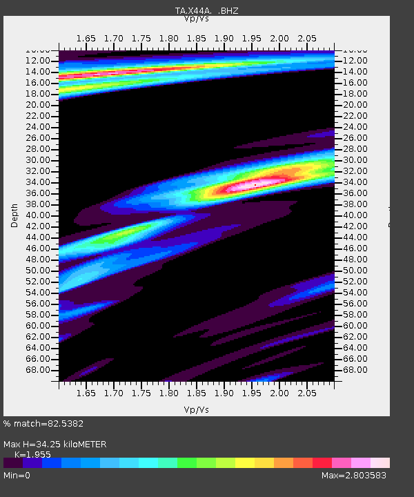
| Estimated Moho Depth: |
34.25 km |
| Estimated Crust Vp/Vs: |
1.96 |
| Assumed Crust Vp: |
6.273 km/s |
| Estimated Crust Vs: |
3.209 km/s |
| Estimated Crust Poisson's Ratio: |
0.32 |
|
| Radial Match: |
82.5382 % |
| Radial Bump: |
289 |
| Transverse Match: |
52.327915 % |
| Transverse Bump: |
390 |
| SOD ConfigId: |
458385 |
| Insert Time: |
2012-10-16 08:27:53.482 +0000 |
| GWidth: |
2.5 |
| Max Bumps: |
400 |
| Tol: |
0.001 |
|

Signal To Noise
| Channel | StoN | STA | LTA |
| TA:X44A: :BHZ:20120604T00:50:52.67501Z | 6.1547923 | 1.704237E-6 | 2.7689595E-7 |
| TA:X44A: :BHN:20120604T00:50:52.67501Z | 3.4431984 | 2.513931E-6 | 7.30115E-7 |
| TA:X44A: :BHE:20120604T00:50:52.67501Z | 1.4452653 | 1.0071453E-6 | 6.968585E-7 |
| Arrivals |
| Ps | 5.6 SECOND |
| PpPs | 15 SECOND |
| PsPs/PpSs | 21 SECOND |


