You are here: Home > Network List > TA - USArray Transportable Network (new EarthScope stations) Stations List
> Station T41A Mountain View, MO, USA > Earthquake Result Viewer
T41A Mountain View, MO, USA - Earthquake Result Viewer

| Earthquake location: |
South Of Panama |
| Earthquake latitude/longitude: |
5.3/-82.6 |
| Earthquake time(UTC): |
2012/06/04 (156) 00:45:15 GMT |
| Earthquake Depth: |
7.0 km |
| Earthquake Magnitude: |
5.9 MB, 5.9 MS, 6.3 MW, 6.2 MW |
| Earthquake Catalog/Contributor: |
WHDF/NEIC |
|
| Network: |
TA USArray Transportable Network (new EarthScope stations) |
| Station: |
T41A Mountain View, MO, USA |
| Lat/Lon: |
37.04 N/91.76 W |
| Elevation: |
366 m |
|
| Distance: |
32.7 deg |
| Az: |
346.393 deg |
| Baz: |
162.975 deg |
| Ray Param: |
0.078555785 |
| Estimated Moho Depth: |
32.0 km |
| Estimated Crust Vp/Vs: |
2.10 |
| Assumed Crust Vp: |
6.53 km/s |
| Estimated Crust Vs: |
3.113 km/s |
| Estimated Crust Poisson's Ratio: |
0.35 |
|
| Radial Match: |
90.72179 % |
| Radial Bump: |
280 |
| Transverse Match: |
51.058628 % |
| Transverse Bump: |
400 |
| SOD ConfigId: |
458385 |
| Insert Time: |
2012-10-16 08:28:08.826 +0000 |
| GWidth: |
2.5 |
| Max Bumps: |
400 |
| Tol: |
0.001 |
|
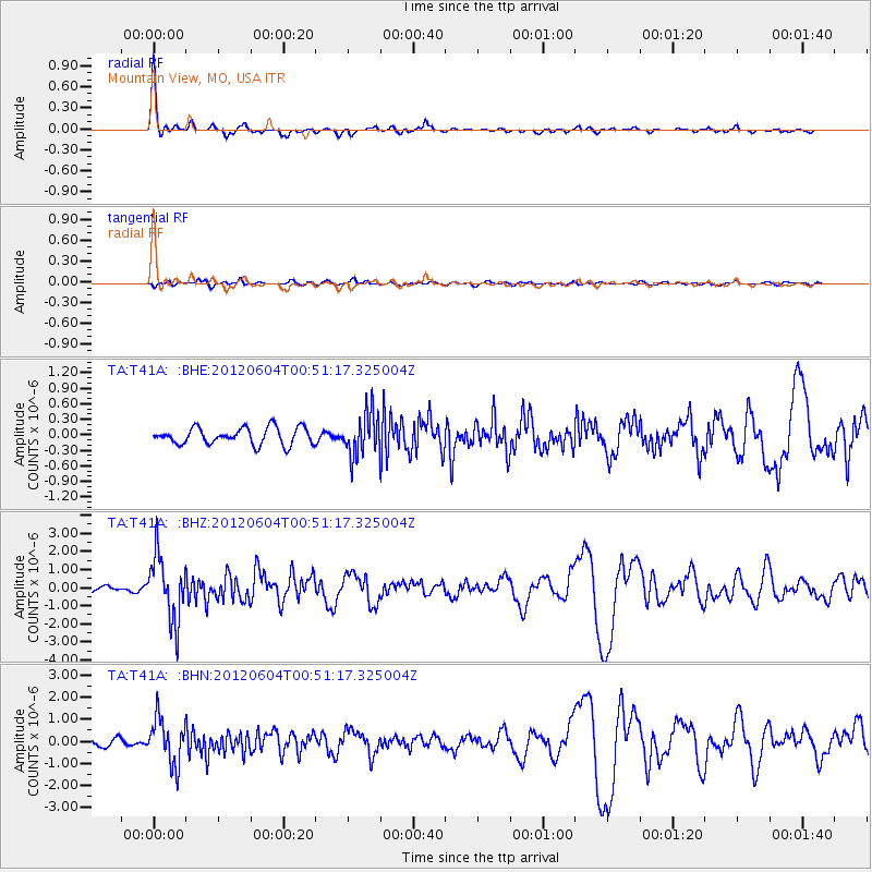
Signal To Noise
| Channel | StoN | STA | LTA |
| TA:T41A: :BHZ:20120604T00:51:17.325004Z | 11.059106 | 1.7874651E-6 | 1.6162835E-7 |
| TA:T41A: :BHN:20120604T00:51:17.325004Z | 5.936636 | 1.0306884E-6 | 1.7361488E-7 |
| TA:T41A: :BHE:20120604T00:51:17.325004Z | 2.5817537 | 4.1831865E-7 | 1.6202888E-7 |
| Arrivals |
| Ps | 5.8 SECOND |
| PpPs | 14 SECOND |
| PsPs/PpSs | 20 SECOND |


