You are here: Home > Network List > TA - USArray Transportable Network (new EarthScope stations) Stations List
> Station Q43A New Douglas, IL, USA > Earthquake Result Viewer
Q43A New Douglas, IL, USA - Earthquake Result Viewer
| Earthquake location: |
South Of Panama |
| Earthquake latitude/longitude: |
5.3/-82.6 |
| Earthquake time(UTC): |
2012/06/04 (156) 00:45:15 GMT |
| Earthquake Depth: |
7.0 km |
| Earthquake Magnitude: |
5.9 MB, 5.9 MS, 6.3 MW, 6.2 MW |
| Earthquake Catalog/Contributor: |
WHDF/NEIC |
|
| Network: |
TA USArray Transportable Network (new EarthScope stations) |
| Station: |
Q43A New Douglas, IL, USA |
| Lat/Lon: |
38.94 N/89.70 W |
| Elevation: |
202 m |
|
| Distance: |
34.1 deg |
| Az: |
350.14 deg |
| Baz: |
167.37 deg |
| Ray Param: |
0.077912875 |
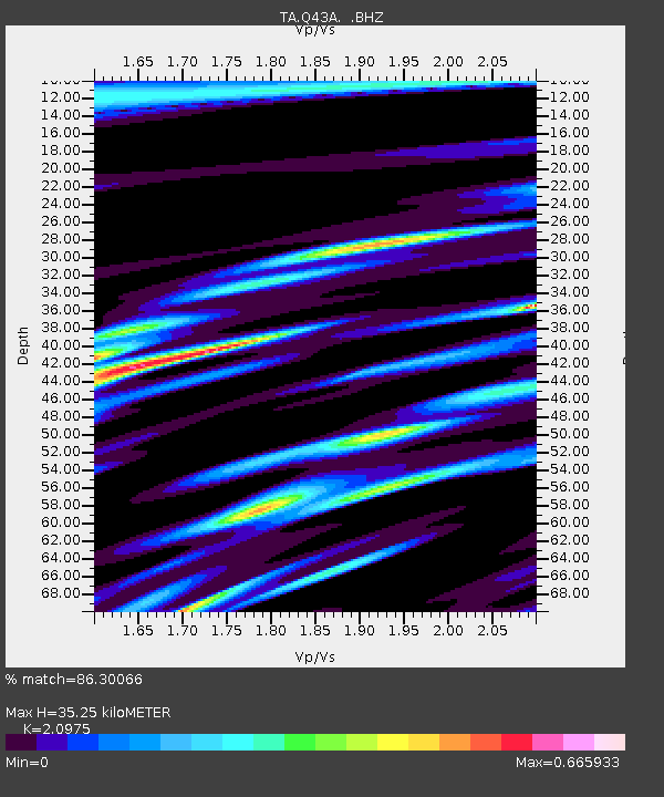
| Estimated Moho Depth: |
35.25 km |
| Estimated Crust Vp/Vs: |
2.10 |
| Assumed Crust Vp: |
6.444 km/s |
| Estimated Crust Vs: |
3.072 km/s |
| Estimated Crust Poisson's Ratio: |
0.35 |
|
| Radial Match: |
86.30066 % |
| Radial Bump: |
381 |
| Transverse Match: |
58.90996 % |
| Transverse Bump: |
400 |
| SOD ConfigId: |
458385 |
| Insert Time: |
2012-10-16 08:29:07.980 +0000 |
| GWidth: |
2.5 |
| Max Bumps: |
400 |
| Tol: |
0.001 |
|

Signal To Noise
| Channel | StoN | STA | LTA |
| TA:Q43A: :BHZ:20120604T00:51:29.599998Z | 15.764043 | 2.370989E-6 | 1.5040489E-7 |
| TA:Q43A: :BHN:20120604T00:51:29.599998Z | 13.832579 | 1.5864046E-6 | 1.1468611E-7 |
| TA:Q43A: :BHE:20120604T00:51:29.599998Z | 3.5547132 | 4.5965913E-7 | 1.2930977E-7 |
| Arrivals |
| Ps | 6.4 SECOND |
| PpPs | 16 SECOND |
| PsPs/PpSs | 22 SECOND |


