You are here: Home > Network List > TA - USArray Transportable Network (new EarthScope stations) Stations List
> Station S41A Jillco Farms, Salem, MO, USA > Earthquake Result Viewer
S41A Jillco Farms, Salem, MO, USA - Earthquake Result Viewer
| Earthquake location: |
South Of Panama |
| Earthquake latitude/longitude: |
5.3/-82.6 |
| Earthquake time(UTC): |
2012/06/04 (156) 00:45:15 GMT |
| Earthquake Depth: |
7.0 km |
| Earthquake Magnitude: |
5.9 MB, 5.9 MS, 6.3 MW, 6.2 MW |
| Earthquake Catalog/Contributor: |
WHDF/NEIC |
|
| Network: |
TA USArray Transportable Network (new EarthScope stations) |
| Station: |
S41A Jillco Farms, Salem, MO, USA |
| Lat/Lon: |
37.59 N/91.75 W |
| Elevation: |
376 m |
|
| Distance: |
33.2 deg |
| Az: |
346.708 deg |
| Baz: |
163.25 deg |
| Ray Param: |
0.07832669 |
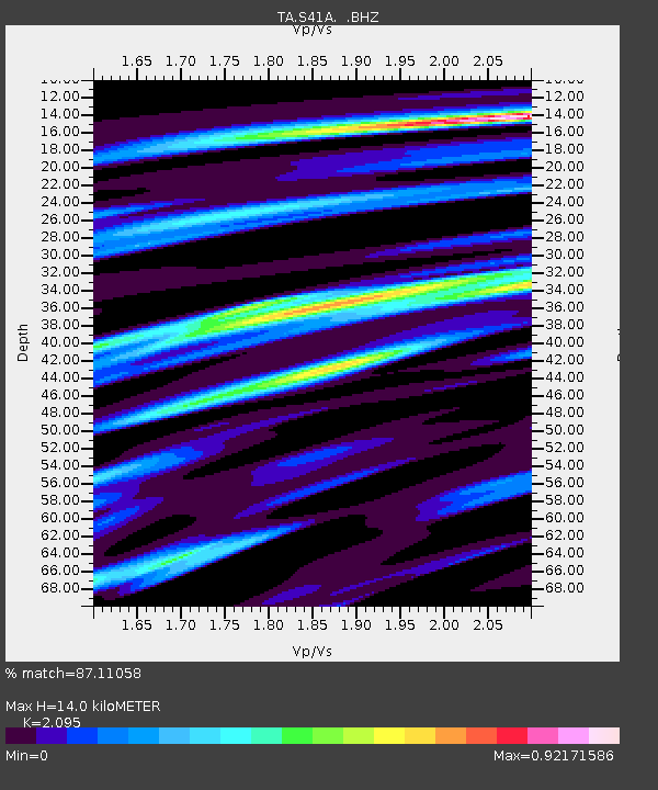
| Estimated Moho Depth: |
14.0 km |
| Estimated Crust Vp/Vs: |
2.10 |
| Assumed Crust Vp: |
6.53 km/s |
| Estimated Crust Vs: |
3.117 km/s |
| Estimated Crust Poisson's Ratio: |
0.35 |
|
| Radial Match: |
87.11058 % |
| Radial Bump: |
400 |
| Transverse Match: |
69.250626 % |
| Transverse Bump: |
400 |
| SOD ConfigId: |
458385 |
| Insert Time: |
2012-10-16 08:29:59.408 +0000 |
| GWidth: |
2.5 |
| Max Bumps: |
400 |
| Tol: |
0.001 |
|
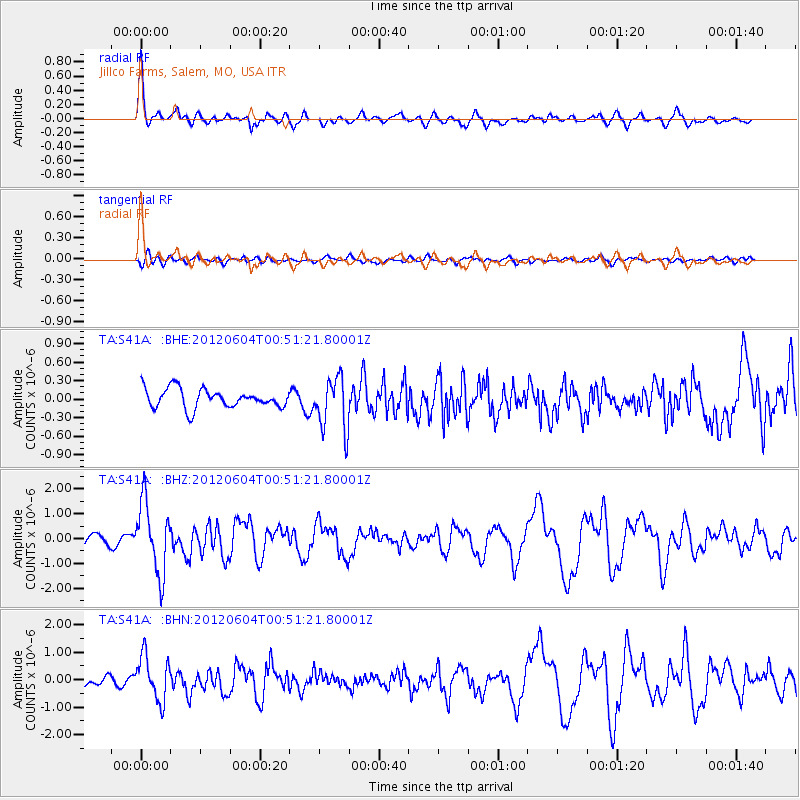
Signal To Noise
| Channel | StoN | STA | LTA |
| TA:S41A: :BHZ:20120604T00:51:21.80001Z | 8.044624 | 1.4148973E-6 | 1.758811E-7 |
| TA:S41A: :BHN:20120604T00:51:21.80001Z | 4.397401 | 8.204876E-7 | 1.8658469E-7 |
| TA:S41A: :BHE:20120604T00:51:21.80001Z | 2.779648 | 4.2829402E-7 | 1.540821E-7 |
| Arrivals |
| Ps | 2.5 SECOND |
| PpPs | 6.2 SECOND |
| PsPs/PpSs | 8.7 SECOND |


