You are here: Home > Network List > NN - Western Great Basin/Eastern Sierra Nevada Stations List
> Station OMMB Old Mammoth Mine, surface, wgs-84 > Earthquake Result Viewer
OMMB Old Mammoth Mine, surface, wgs-84 - Earthquake Result Viewer
| Earthquake location: |
Samoa Islands Region |
| Earthquake latitude/longitude: |
-14.8/-175.4 |
| Earthquake time(UTC): |
2014/05/18 (138) 00:58:29 GMT |
| Earthquake Depth: |
26 km |
| Earthquake Magnitude: |
5.6 MW |
| Earthquake Catalog/Contributor: |
ISC/ISC |
|
| Network: |
NN Western Great Basin/Eastern Sierra Nevada |
| Station: |
OMMB Old Mammoth Mine, surface, wgs-84 |
| Lat/Lon: |
37.61 N/119.00 W |
| Elevation: |
2768 m |
|
| Distance: |
74.3 deg |
| Az: |
43.426 deg |
| Baz: |
236.864 deg |
| Ray Param: |
0.05239554 |
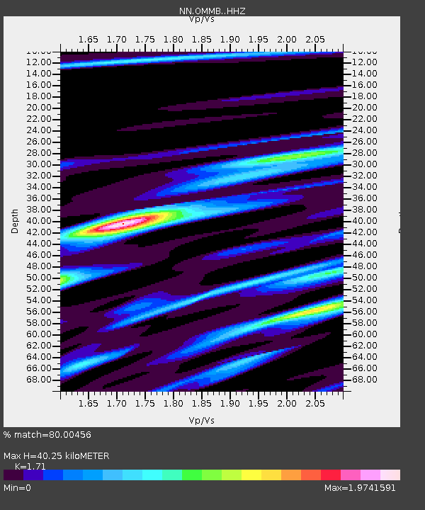
| Estimated Moho Depth: |
40.25 km |
| Estimated Crust Vp/Vs: |
1.71 |
| Assumed Crust Vp: |
6.291 km/s |
| Estimated Crust Vs: |
3.679 km/s |
| Estimated Crust Poisson's Ratio: |
0.24 |
|
| Radial Match: |
80.00456 % |
| Radial Bump: |
400 |
| Transverse Match: |
42.19309 % |
| Transverse Bump: |
400 |
| SOD ConfigId: |
3390531 |
| Insert Time: |
2019-04-11 22:42:06.855 +0000 |
| GWidth: |
2.5 |
| Max Bumps: |
400 |
| Tol: |
0.001 |
|

Signal To Noise
| Channel | StoN | STA | LTA |
| NN:OMMB: :HHZ:20140518T01:09:33.384983Z | 1.9390744 | 1.2701878E-7 | 6.550485E-8 |
| NN:OMMB: :HHN:20140518T01:09:33.384983Z | 1.9377981 | 1.7128787E-7 | 8.839304E-8 |
| NN:OMMB: :HHE:20140518T01:09:33.384983Z | 2.2278628 | 1.3648547E-7 | 6.126296E-8 |
| Arrivals |
| Ps | 4.7 SECOND |
| PpPs | 17 SECOND |
| PsPs/PpSs | 21 SECOND |


