You are here: Home > Network List > TA - USArray Transportable Network (new EarthScope stations) Stations List
> Station R42A Luebbering, MO, USA > Earthquake Result Viewer
R42A Luebbering, MO, USA - Earthquake Result Viewer
| Earthquake location: |
South Of Panama |
| Earthquake latitude/longitude: |
5.3/-82.6 |
| Earthquake time(UTC): |
2012/06/04 (156) 00:45:15 GMT |
| Earthquake Depth: |
7.0 km |
| Earthquake Magnitude: |
5.9 MB, 5.9 MS, 6.3 MW, 6.2 MW |
| Earthquake Catalog/Contributor: |
WHDF/NEIC |
|
| Network: |
TA USArray Transportable Network (new EarthScope stations) |
| Station: |
R42A Luebbering, MO, USA |
| Lat/Lon: |
38.28 N/90.79 W |
| Elevation: |
218 m |
|
| Distance: |
33.7 deg |
| Az: |
348.363 deg |
| Baz: |
165.214 deg |
| Ray Param: |
0.078114346 |
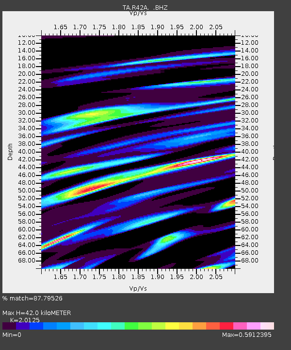
| Estimated Moho Depth: |
42.0 km |
| Estimated Crust Vp/Vs: |
2.01 |
| Assumed Crust Vp: |
6.498 km/s |
| Estimated Crust Vs: |
3.229 km/s |
| Estimated Crust Poisson's Ratio: |
0.34 |
|
| Radial Match: |
87.79526 % |
| Radial Bump: |
378 |
| Transverse Match: |
67.882416 % |
| Transverse Bump: |
400 |
| SOD ConfigId: |
458385 |
| Insert Time: |
2012-10-16 08:30:42.115 +0000 |
| GWidth: |
2.5 |
| Max Bumps: |
400 |
| Tol: |
0.001 |
|
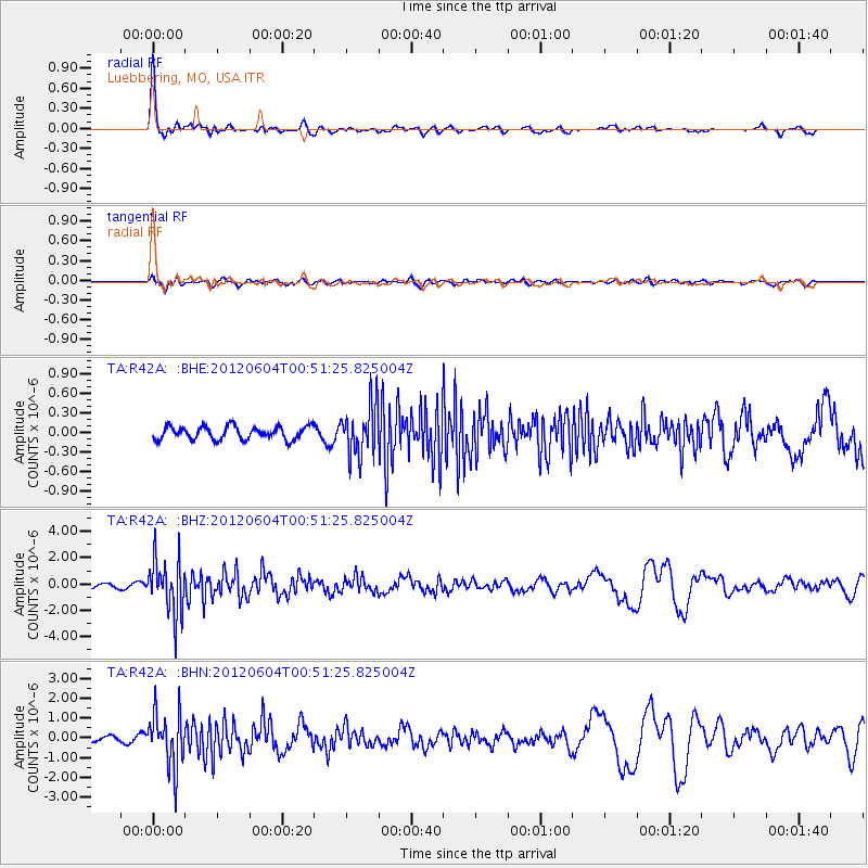
Signal To Noise
| Channel | StoN | STA | LTA |
| TA:R42A: :BHZ:20120604T00:51:25.825004Z | 17.209051 | 2.0958166E-6 | 1.2178572E-7 |
| TA:R42A: :BHN:20120604T00:51:25.825004Z | 12.951993 | 1.3987278E-6 | 1.07993245E-7 |
| TA:R42A: :BHE:20120604T00:51:25.825004Z | 3.9424982 | 3.921111E-7 | 9.945752E-8 |
| Arrivals |
| Ps | 7.0 SECOND |
| PpPs | 18 SECOND |
| PsPs/PpSs | 25 SECOND |


