You are here: Home > Network List > TA - USArray Transportable Network (new EarthScope stations) Stations List
> Station W43A Forest City, AR, USA > Earthquake Result Viewer
W43A Forest City, AR, USA - Earthquake Result Viewer
| Earthquake location: |
South Of Panama |
| Earthquake latitude/longitude: |
5.3/-82.6 |
| Earthquake time(UTC): |
2012/06/04 (156) 00:45:15 GMT |
| Earthquake Depth: |
7.0 km |
| Earthquake Magnitude: |
5.9 MB, 5.9 MS, 6.3 MW, 6.2 MW |
| Earthquake Catalog/Contributor: |
WHDF/NEIC |
|
| Network: |
TA USArray Transportable Network (new EarthScope stations) |
| Station: |
W43A Forest City, AR, USA |
| Lat/Lon: |
35.09 N/90.71 W |
| Elevation: |
70 m |
|
| Distance: |
30.6 deg |
| Az: |
346.903 deg |
| Baz: |
164.029 deg |
| Ray Param: |
0.07930299 |
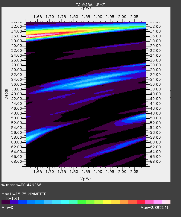
| Estimated Moho Depth: |
15.75 km |
| Estimated Crust Vp/Vs: |
1.61 |
| Assumed Crust Vp: |
6.273 km/s |
| Estimated Crust Vs: |
3.896 km/s |
| Estimated Crust Poisson's Ratio: |
0.19 |
|
| Radial Match: |
80.446266 % |
| Radial Bump: |
400 |
| Transverse Match: |
56.91145 % |
| Transverse Bump: |
400 |
| SOD ConfigId: |
458385 |
| Insert Time: |
2012-10-16 08:31:17.712 +0000 |
| GWidth: |
2.5 |
| Max Bumps: |
400 |
| Tol: |
0.001 |
|

Signal To Noise
| Channel | StoN | STA | LTA |
| TA:W43A: :BHZ:20120604T00:50:58.749991Z | 8.998929 | 2.7178053E-6 | 3.0201429E-7 |
| TA:W43A: :BHN:20120604T00:50:58.749991Z | 4.0476522 | 2.6664302E-6 | 6.5875963E-7 |
| TA:W43A: :BHE:20120604T00:50:58.749991Z | 1.0767583 | 8.95486E-7 | 8.3165E-7 |
| Arrivals |
| Ps | 1.7 SECOND |
| PpPs | 6.0 SECOND |
| PsPs/PpSs | 7.7 SECOND |


