You are here: Home > Network List > TA - USArray Transportable Network (new EarthScope stations) Stations List
> Station H40A Chili, WI, USA > Earthquake Result Viewer
H40A Chili, WI, USA - Earthquake Result Viewer
| Earthquake location: |
South Of Panama |
| Earthquake latitude/longitude: |
5.3/-82.6 |
| Earthquake time(UTC): |
2012/06/04 (156) 00:45:15 GMT |
| Earthquake Depth: |
7.0 km |
| Earthquake Magnitude: |
5.9 MB, 5.9 MS, 6.3 MW, 6.2 MW |
| Earthquake Catalog/Contributor: |
WHDF/NEIC |
|
| Network: |
TA USArray Transportable Network (new EarthScope stations) |
| Station: |
H40A Chili, WI, USA |
| Lat/Lon: |
44.62 N/90.39 W |
| Elevation: |
372 m |
|
| Distance: |
39.7 deg |
| Az: |
351.325 deg |
| Baz: |
167.859 deg |
| Ray Param: |
0.07481319 |
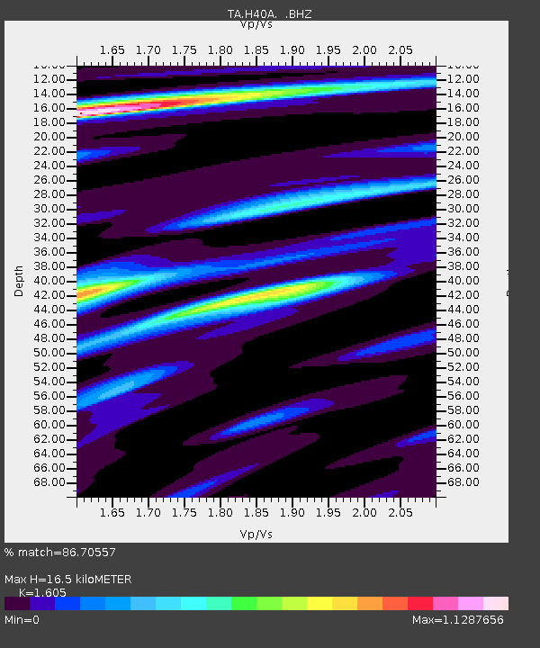
| Estimated Moho Depth: |
16.5 km |
| Estimated Crust Vp/Vs: |
1.61 |
| Assumed Crust Vp: |
6.571 km/s |
| Estimated Crust Vs: |
4.094 km/s |
| Estimated Crust Poisson's Ratio: |
0.18 |
|
| Radial Match: |
86.70557 % |
| Radial Bump: |
262 |
| Transverse Match: |
65.45341 % |
| Transverse Bump: |
400 |
| SOD ConfigId: |
458385 |
| Insert Time: |
2012-10-16 08:31:38.792 +0000 |
| GWidth: |
2.5 |
| Max Bumps: |
400 |
| Tol: |
0.001 |
|
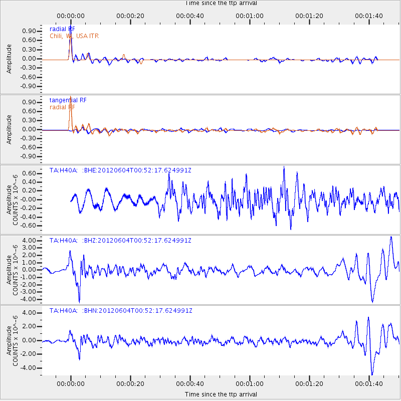
Signal To Noise
| Channel | StoN | STA | LTA |
| TA:H40A: :BHZ:20120604T00:52:17.624991Z | 7.6123257 | 1.7452402E-6 | 2.2926504E-7 |
| TA:H40A: :BHN:20120604T00:52:17.624991Z | 8.093533 | 1.0121847E-6 | 1.2506092E-7 |
| TA:H40A: :BHE:20120604T00:52:17.624991Z | 1.9301025 | 2.619599E-7 | 1.3572331E-7 |
| Arrivals |
| Ps | 1.6 SECOND |
| PpPs | 6.0 SECOND |
| PsPs/PpSs | 7.7 SECOND |


