You are here: Home > Network List > TA - USArray Transportable Network (new EarthScope stations) Stations List
> Station R43A Red Bud, IL, USA > Earthquake Result Viewer
R43A Red Bud, IL, USA - Earthquake Result Viewer
| Earthquake location: |
South Of Panama |
| Earthquake latitude/longitude: |
5.3/-82.6 |
| Earthquake time(UTC): |
2012/06/04 (156) 00:45:15 GMT |
| Earthquake Depth: |
7.0 km |
| Earthquake Magnitude: |
5.9 MB, 5.9 MS, 6.3 MW, 6.2 MW |
| Earthquake Catalog/Contributor: |
WHDF/NEIC |
|
| Network: |
TA USArray Transportable Network (new EarthScope stations) |
| Station: |
R43A Red Bud, IL, USA |
| Lat/Lon: |
38.28 N/89.93 W |
| Elevation: |
186 m |
|
| Distance: |
33.5 deg |
| Az: |
349.554 deg |
| Baz: |
166.739 deg |
| Ray Param: |
0.07819215 |
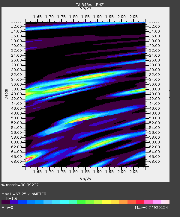
| Estimated Moho Depth: |
67.25 km |
| Estimated Crust Vp/Vs: |
1.60 |
| Assumed Crust Vp: |
6.444 km/s |
| Estimated Crust Vs: |
4.027 km/s |
| Estimated Crust Poisson's Ratio: |
0.18 |
|
| Radial Match: |
90.99237 % |
| Radial Bump: |
316 |
| Transverse Match: |
67.71615 % |
| Transverse Bump: |
400 |
| SOD ConfigId: |
458385 |
| Insert Time: |
2012-10-16 08:31:46.304 +0000 |
| GWidth: |
2.5 |
| Max Bumps: |
400 |
| Tol: |
0.001 |
|

Signal To Noise
| Channel | StoN | STA | LTA |
| TA:R43A: :BHZ:20120604T00:51:24.349998Z | 27.962372 | 4.1585936E-6 | 1.4872106E-7 |
| TA:R43A: :BHN:20120604T00:51:24.349998Z | 22.127785 | 2.6586383E-6 | 1.2014932E-7 |
| TA:R43A: :BHE:20120604T00:51:24.349998Z | 6.8051343 | 8.987639E-7 | 1.3207145E-7 |
| Arrivals |
| Ps | 6.8 SECOND |
| PpPs | 25 SECOND |
| PsPs/PpSs | 32 SECOND |


