You are here: Home > Network List > TA - USArray Transportable Network (new EarthScope stations) Stations List
> Station H41A Junction City, WI, USA > Earthquake Result Viewer
H41A Junction City, WI, USA - Earthquake Result Viewer

| Earthquake location: |
South Of Panama |
| Earthquake latitude/longitude: |
5.3/-82.6 |
| Earthquake time(UTC): |
2012/06/04 (156) 00:45:15 GMT |
| Earthquake Depth: |
7.0 km |
| Earthquake Magnitude: |
5.9 MB, 5.9 MS, 6.3 MW, 6.2 MW |
| Earthquake Catalog/Contributor: |
WHDF/NEIC |
|
| Network: |
TA USArray Transportable Network (new EarthScope stations) |
| Station: |
H41A Junction City, WI, USA |
| Lat/Lon: |
44.62 N/89.65 W |
| Elevation: |
348 m |
|
| Distance: |
39.6 deg |
| Az: |
352.131 deg |
| Baz: |
168.995 deg |
| Ray Param: |
0.07487731 |
| Estimated Moho Depth: |
22.0 km |
| Estimated Crust Vp/Vs: |
1.61 |
| Assumed Crust Vp: |
6.41 km/s |
| Estimated Crust Vs: |
3.994 km/s |
| Estimated Crust Poisson's Ratio: |
0.18 |
|
| Radial Match: |
88.84716 % |
| Radial Bump: |
292 |
| Transverse Match: |
60.87492 % |
| Transverse Bump: |
400 |
| SOD ConfigId: |
458385 |
| Insert Time: |
2012-10-16 08:32:12.583 +0000 |
| GWidth: |
2.5 |
| Max Bumps: |
400 |
| Tol: |
0.001 |
|
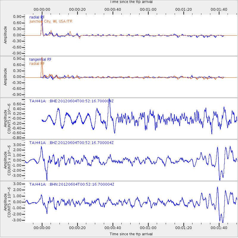
Signal To Noise
| Channel | StoN | STA | LTA |
| TA:H41A: :BHZ:20120604T00:52:16.700004Z | 5.453623 | 1.6094634E-6 | 2.951182E-7 |
| TA:H41A: :BHN:20120604T00:52:16.700004Z | 5.27943 | 7.771066E-7 | 1.4719518E-7 |
| TA:H41A: :BHE:20120604T00:52:16.700004Z | 1.4846714 | 2.612605E-7 | 1.7597195E-7 |
| Arrivals |
| Ps | 2.2 SECOND |
| PpPs | 8.3 SECOND |
| PsPs/PpSs | 11 SECOND |


