You are here: Home > Network List > TA - USArray Transportable Network (new EarthScope stations) Stations List
> Station G39A Holcombe, WI, USA > Earthquake Result Viewer
G39A Holcombe, WI, USA - Earthquake Result Viewer
| Earthquake location: |
South Of Panama |
| Earthquake latitude/longitude: |
5.3/-82.6 |
| Earthquake time(UTC): |
2012/06/04 (156) 00:45:15 GMT |
| Earthquake Depth: |
7.0 km |
| Earthquake Magnitude: |
5.9 MB, 5.9 MS, 6.3 MW, 6.2 MW |
| Earthquake Catalog/Contributor: |
WHDF/NEIC |
|
| Network: |
TA USArray Transportable Network (new EarthScope stations) |
| Station: |
G39A Holcombe, WI, USA |
| Lat/Lon: |
45.29 N/91.17 W |
| Elevation: |
350 m |
|
| Distance: |
40.5 deg |
| Az: |
350.713 deg |
| Baz: |
166.842 deg |
| Ray Param: |
0.07436356 |
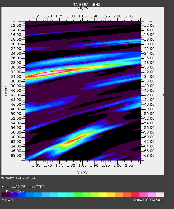
| Estimated Moho Depth: |
32.25 km |
| Estimated Crust Vp/Vs: |
1.70 |
| Assumed Crust Vp: |
6.571 km/s |
| Estimated Crust Vs: |
3.859 km/s |
| Estimated Crust Poisson's Ratio: |
0.24 |
|
| Radial Match: |
89.95541 % |
| Radial Bump: |
241 |
| Transverse Match: |
67.986374 % |
| Transverse Bump: |
400 |
| SOD ConfigId: |
458385 |
| Insert Time: |
2012-10-16 08:32:33.601 +0000 |
| GWidth: |
2.5 |
| Max Bumps: |
400 |
| Tol: |
0.001 |
|

Signal To Noise
| Channel | StoN | STA | LTA |
| TA:G39A: :BHZ:20120604T00:52:23.999991Z | 12.825338 | 2.372806E-6 | 1.8500923E-7 |
| TA:G39A: :BHN:20120604T00:52:23.999991Z | 9.28421 | 1.5229252E-6 | 1.640339E-7 |
| TA:G39A: :BHE:20120604T00:52:23.999991Z | 6.5762773 | 6.468161E-7 | 9.835597E-8 |
| Arrivals |
| Ps | 3.7 SECOND |
| PpPs | 12 SECOND |
| PsPs/PpSs | 16 SECOND |


