You are here: Home > Network List > TA - USArray Transportable Network (new EarthScope stations) Stations List
> Station N40A Mertquake, Salem, IA, USA > Earthquake Result Viewer
N40A Mertquake, Salem, IA, USA - Earthquake Result Viewer
| Earthquake location: |
South Of Panama |
| Earthquake latitude/longitude: |
5.3/-82.6 |
| Earthquake time(UTC): |
2012/06/04 (156) 00:45:15 GMT |
| Earthquake Depth: |
7.0 km |
| Earthquake Magnitude: |
5.9 MB, 5.9 MS, 6.3 MW, 6.2 MW |
| Earthquake Catalog/Contributor: |
WHDF/NEIC |
|
| Network: |
TA USArray Transportable Network (new EarthScope stations) |
| Station: |
N40A Mertquake, Salem, IA, USA |
| Lat/Lon: |
40.88 N/91.58 W |
| Elevation: |
208 m |
|
| Distance: |
36.3 deg |
| Az: |
348.508 deg |
| Baz: |
164.831 deg |
| Ray Param: |
0.07675017 |
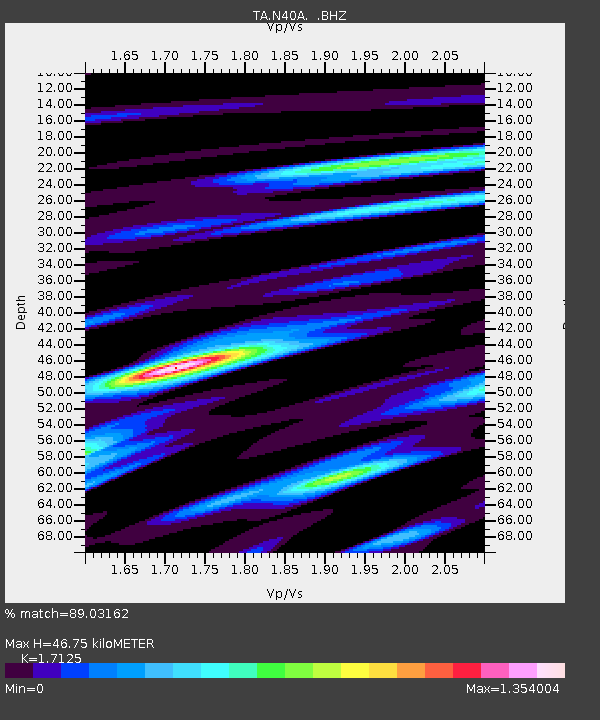
| Estimated Moho Depth: |
46.75 km |
| Estimated Crust Vp/Vs: |
1.71 |
| Assumed Crust Vp: |
6.498 km/s |
| Estimated Crust Vs: |
3.794 km/s |
| Estimated Crust Poisson's Ratio: |
0.24 |
|
| Radial Match: |
89.03162 % |
| Radial Bump: |
400 |
| Transverse Match: |
64.53165 % |
| Transverse Bump: |
400 |
| SOD ConfigId: |
458385 |
| Insert Time: |
2012-10-16 08:33:15.211 +0000 |
| GWidth: |
2.5 |
| Max Bumps: |
400 |
| Tol: |
0.001 |
|
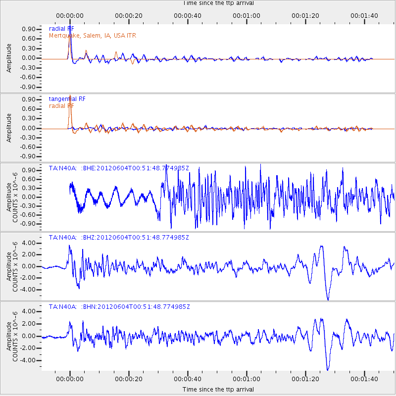
Signal To Noise
| Channel | StoN | STA | LTA |
| TA:N40A: :BHZ:20120604T00:51:48.774985Z | 10.3566475 | 2.1323106E-6 | 2.0588811E-7 |
| TA:N40A: :BHN:20120604T00:51:48.774985Z | 8.267047 | 1.3900788E-6 | 1.6814694E-7 |
| TA:N40A: :BHE:20120604T00:51:48.774985Z | 2.4506078 | 5.2751477E-7 | 2.1525874E-7 |
| Arrivals |
| Ps | 5.6 SECOND |
| PpPs | 18 SECOND |
| PsPs/PpSs | 24 SECOND |


