You are here: Home > Network List > TA - USArray Transportable Network (new EarthScope stations) Stations List
> Station M40A Post Highland Seismo, Ainsworth, IA, USA > Earthquake Result Viewer
M40A Post Highland Seismo, Ainsworth, IA, USA - Earthquake Result Viewer
| Earthquake location: |
South Of Panama |
| Earthquake latitude/longitude: |
5.3/-82.6 |
| Earthquake time(UTC): |
2012/06/04 (156) 00:45:15 GMT |
| Earthquake Depth: |
7.0 km |
| Earthquake Magnitude: |
5.9 MB, 5.9 MS, 6.3 MW, 6.2 MW |
| Earthquake Catalog/Contributor: |
WHDF/NEIC |
|
| Network: |
TA USArray Transportable Network (new EarthScope stations) |
| Station: |
M40A Post Highland Seismo, Ainsworth, IA, USA |
| Lat/Lon: |
41.41 N/91.51 W |
| Elevation: |
223 m |
|
| Distance: |
36.8 deg |
| Az: |
348.822 deg |
| Baz: |
165.131 deg |
| Ray Param: |
0.07648343 |
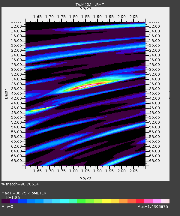
| Estimated Moho Depth: |
36.75 km |
| Estimated Crust Vp/Vs: |
1.85 |
| Assumed Crust Vp: |
6.498 km/s |
| Estimated Crust Vs: |
3.512 km/s |
| Estimated Crust Poisson's Ratio: |
0.29 |
|
| Radial Match: |
90.78514 % |
| Radial Bump: |
400 |
| Transverse Match: |
63.721268 % |
| Transverse Bump: |
400 |
| SOD ConfigId: |
458385 |
| Insert Time: |
2012-10-16 08:33:18.868 +0000 |
| GWidth: |
2.5 |
| Max Bumps: |
400 |
| Tol: |
0.001 |
|
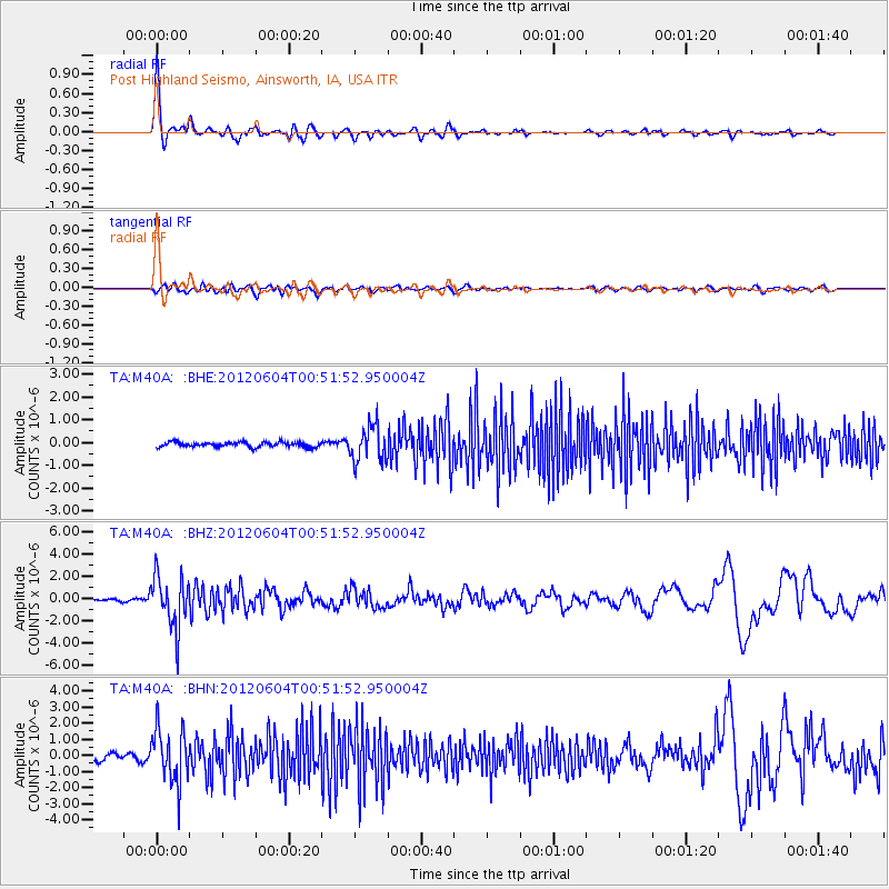
Signal To Noise
| Channel | StoN | STA | LTA |
| TA:M40A: :BHZ:20120604T00:51:52.950004Z | 18.749763 | 2.3312998E-6 | 1.2433756E-7 |
| TA:M40A: :BHN:20120604T00:51:52.950004Z | 9.613284 | 1.6786755E-6 | 1.746204E-7 |
| TA:M40A: :BHE:20120604T00:51:52.950004Z | 7.333191 | 7.8769045E-7 | 1.0741442E-7 |
| Arrivals |
| Ps | 5.2 SECOND |
| PpPs | 15 SECOND |
| PsPs/PpSs | 20 SECOND |


