You are here: Home > Network List > TA - USArray Transportable Network (new EarthScope stations) Stations List
> Station E38A The Farm, Brule, WI, USA > Earthquake Result Viewer
E38A The Farm, Brule, WI, USA - Earthquake Result Viewer
| Earthquake location: |
South Of Panama |
| Earthquake latitude/longitude: |
5.3/-82.6 |
| Earthquake time(UTC): |
2012/06/04 (156) 00:45:15 GMT |
| Earthquake Depth: |
7.0 km |
| Earthquake Magnitude: |
5.9 MB, 5.9 MS, 6.3 MW, 6.2 MW |
| Earthquake Catalog/Contributor: |
WHDF/NEIC |
|
| Network: |
TA USArray Transportable Network (new EarthScope stations) |
| Station: |
E38A The Farm, Brule, WI, USA |
| Lat/Lon: |
46.61 N/91.55 W |
| Elevation: |
341 m |
|
| Distance: |
41.9 deg |
| Az: |
350.777 deg |
| Baz: |
166.615 deg |
| Ray Param: |
0.07353054 |
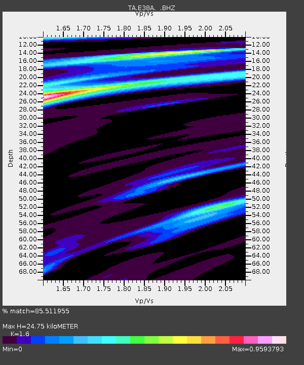
| Estimated Moho Depth: |
24.75 km |
| Estimated Crust Vp/Vs: |
1.60 |
| Assumed Crust Vp: |
6.467 km/s |
| Estimated Crust Vs: |
4.042 km/s |
| Estimated Crust Poisson's Ratio: |
0.18 |
|
| Radial Match: |
85.511955 % |
| Radial Bump: |
271 |
| Transverse Match: |
36.550297 % |
| Transverse Bump: |
400 |
| SOD ConfigId: |
458385 |
| Insert Time: |
2012-10-16 08:33:36.092 +0000 |
| GWidth: |
2.5 |
| Max Bumps: |
400 |
| Tol: |
0.001 |
|

Signal To Noise
| Channel | StoN | STA | LTA |
| TA:E38A: :BHZ:20120604T00:52:35.05001Z | 7.521517 | 1.9059372E-6 | 2.5339799E-7 |
| TA:E38A: :BHN:20120604T00:52:35.05001Z | 3.2712529 | 9.428098E-7 | 2.882106E-7 |
| TA:E38A: :BHE:20120604T00:52:35.05001Z | 0.83931124 | 2.5506995E-7 | 3.039039E-7 |
| Arrivals |
| Ps | 2.5 SECOND |
| PpPs | 9.2 SECOND |
| PsPs/PpSs | 12 SECOND |


