You are here: Home > Network List > TA - USArray Transportable Network (new EarthScope stations) Stations List
> Station L43A Garden Prairie, IL, USA > Earthquake Result Viewer
L43A Garden Prairie, IL, USA - Earthquake Result Viewer
| Earthquake location: |
South Of Panama |
| Earthquake latitude/longitude: |
5.3/-82.6 |
| Earthquake time(UTC): |
2012/06/04 (156) 00:45:15 GMT |
| Earthquake Depth: |
7.0 km |
| Earthquake Magnitude: |
5.9 MB, 5.9 MS, 6.3 MW, 6.2 MW |
| Earthquake Catalog/Contributor: |
WHDF/NEIC |
|
| Network: |
TA USArray Transportable Network (new EarthScope stations) |
| Station: |
L43A Garden Prairie, IL, USA |
| Lat/Lon: |
42.18 N/88.74 W |
| Elevation: |
266 m |
|
| Distance: |
37.1 deg |
| Az: |
352.464 deg |
| Baz: |
169.88 deg |
| Ray Param: |
0.07631443 |
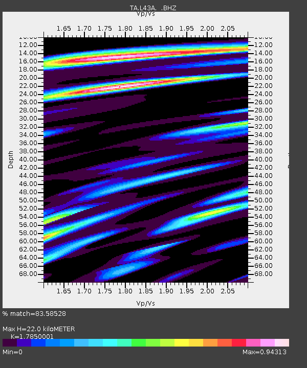
| Estimated Moho Depth: |
22.0 km |
| Estimated Crust Vp/Vs: |
1.79 |
| Assumed Crust Vp: |
6.571 km/s |
| Estimated Crust Vs: |
3.681 km/s |
| Estimated Crust Poisson's Ratio: |
0.27 |
|
| Radial Match: |
83.58528 % |
| Radial Bump: |
361 |
| Transverse Match: |
49.298035 % |
| Transverse Bump: |
400 |
| SOD ConfigId: |
458385 |
| Insert Time: |
2012-10-16 08:34:30.187 +0000 |
| GWidth: |
2.5 |
| Max Bumps: |
400 |
| Tol: |
0.001 |
|
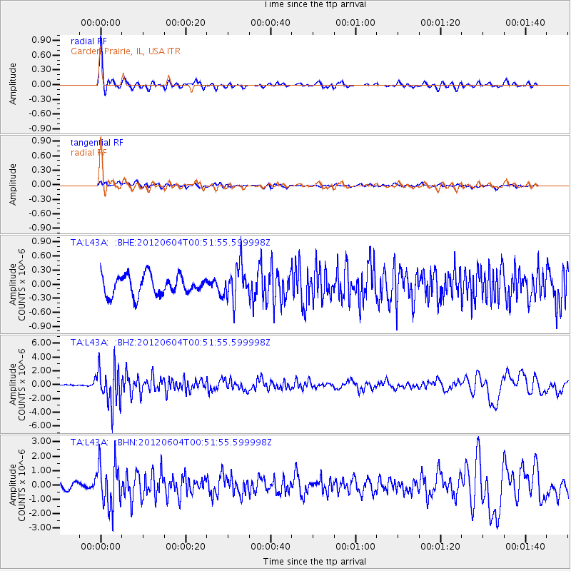
Signal To Noise
| Channel | StoN | STA | LTA |
| TA:L43A: :BHZ:20120604T00:51:55.599998Z | 11.427028 | 2.7466217E-6 | 2.4036189E-7 |
| TA:L43A: :BHN:20120604T00:51:55.599998Z | 8.007997 | 1.5360858E-6 | 1.91819E-7 |
| TA:L43A: :BHE:20120604T00:51:55.599998Z | 1.7546141 | 3.6131834E-7 | 2.0592468E-7 |
| Arrivals |
| Ps | 2.8 SECOND |
| PpPs | 8.6 SECOND |
| PsPs/PpSs | 11 SECOND |


