You are here: Home > Network List > TA - USArray Transportable Network (new EarthScope stations) Stations List
> Station E44A Grand Marais Airport, Grand Marais, MI, USA > Earthquake Result Viewer
E44A Grand Marais Airport, Grand Marais, MI, USA - Earthquake Result Viewer
| Earthquake location: |
South Of Panama |
| Earthquake latitude/longitude: |
5.3/-82.6 |
| Earthquake time(UTC): |
2012/06/04 (156) 00:45:15 GMT |
| Earthquake Depth: |
7.0 km |
| Earthquake Magnitude: |
5.9 MB, 5.9 MS, 6.3 MW, 6.2 MW |
| Earthquake Catalog/Contributor: |
WHDF/NEIC |
|
| Network: |
TA USArray Transportable Network (new EarthScope stations) |
| Station: |
E44A Grand Marais Airport, Grand Marais, MI, USA |
| Lat/Lon: |
46.62 N/85.92 W |
| Elevation: |
282 m |
|
| Distance: |
41.3 deg |
| Az: |
356.558 deg |
| Baz: |
175.025 deg |
| Ray Param: |
0.07391424 |
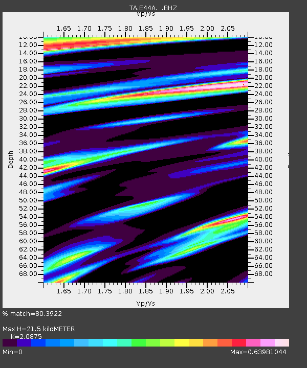
| Estimated Moho Depth: |
21.5 km |
| Estimated Crust Vp/Vs: |
2.09 |
| Assumed Crust Vp: |
6.467 km/s |
| Estimated Crust Vs: |
3.098 km/s |
| Estimated Crust Poisson's Ratio: |
0.35 |
|
| Radial Match: |
80.3922 % |
| Radial Bump: |
400 |
| Transverse Match: |
56.85849 % |
| Transverse Bump: |
400 |
| SOD ConfigId: |
458385 |
| Insert Time: |
2012-10-16 08:34:42.627 +0000 |
| GWidth: |
2.5 |
| Max Bumps: |
400 |
| Tol: |
0.001 |
|
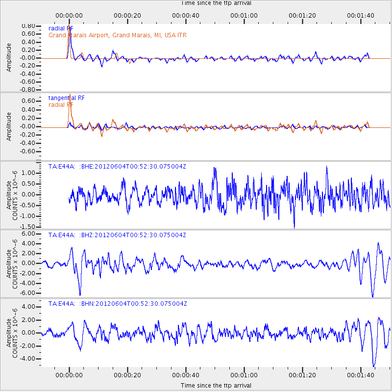
Signal To Noise
| Channel | StoN | STA | LTA |
| TA:E44A: :BHZ:20120604T00:52:30.075004Z | 9.342964 | 2.5395825E-6 | 2.7181764E-7 |
| TA:E44A: :BHN:20120604T00:52:30.075004Z | 2.4306433 | 1.3488593E-6 | 5.549392E-7 |
| TA:E44A: :BHE:20120604T00:52:30.075004Z | 0.8691415 | 2.7484808E-7 | 3.1622935E-7 |
| Arrivals |
| Ps | 3.8 SECOND |
| PpPs | 9.7 SECOND |
| PsPs/PpSs | 14 SECOND |


