You are here: Home > Network List > TA - USArray Transportable Network (new EarthScope stations) Stations List
> Station H42A Shiocton, WI, USA > Earthquake Result Viewer
H42A Shiocton, WI, USA - Earthquake Result Viewer
| Earthquake location: |
South Of Panama |
| Earthquake latitude/longitude: |
5.3/-82.6 |
| Earthquake time(UTC): |
2012/06/04 (156) 00:45:15 GMT |
| Earthquake Depth: |
7.0 km |
| Earthquake Magnitude: |
5.9 MB, 5.9 MS, 6.3 MW, 6.2 MW |
| Earthquake Catalog/Contributor: |
WHDF/NEIC |
|
| Network: |
TA USArray Transportable Network (new EarthScope stations) |
| Station: |
H42A Shiocton, WI, USA |
| Lat/Lon: |
44.51 N/88.53 W |
| Elevation: |
244 m |
|
| Distance: |
39.4 deg |
| Az: |
353.342 deg |
| Baz: |
170.714 deg |
| Ray Param: |
0.075019956 |
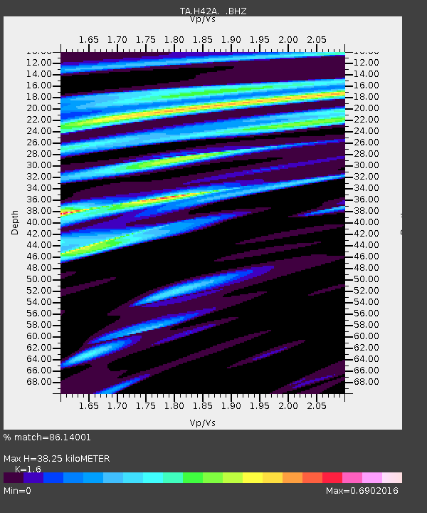
| Estimated Moho Depth: |
38.25 km |
| Estimated Crust Vp/Vs: |
1.60 |
| Assumed Crust Vp: |
6.41 km/s |
| Estimated Crust Vs: |
4.006 km/s |
| Estimated Crust Poisson's Ratio: |
0.18 |
|
| Radial Match: |
86.14001 % |
| Radial Bump: |
311 |
| Transverse Match: |
45.336864 % |
| Transverse Bump: |
400 |
| SOD ConfigId: |
458385 |
| Insert Time: |
2012-10-16 08:35:02.915 +0000 |
| GWidth: |
2.5 |
| Max Bumps: |
400 |
| Tol: |
0.001 |
|

Signal To Noise
| Channel | StoN | STA | LTA |
| TA:H42A: :BHZ:20120604T00:52:14.649985Z | 6.7745814 | 1.6485833E-6 | 2.4334838E-7 |
| TA:H42A: :BHN:20120604T00:52:14.649985Z | 3.841659 | 1.2539663E-6 | 3.2641267E-7 |
| TA:H42A: :BHE:20120604T00:52:14.649985Z | 1.7527926 | 5.752778E-7 | 3.2820643E-7 |
| Arrivals |
| Ps | 3.9 SECOND |
| PpPs | 14 SECOND |
| PsPs/PpSs | 18 SECOND |


