You are here: Home > Network List > TA - USArray Transportable Network (new EarthScope stations) Stations List
> Station O44A Mansfield, IL, USA > Earthquake Result Viewer
O44A Mansfield, IL, USA - Earthquake Result Viewer

| Earthquake location: |
South Of Panama |
| Earthquake latitude/longitude: |
5.3/-82.6 |
| Earthquake time(UTC): |
2012/06/04 (156) 00:45:15 GMT |
| Earthquake Depth: |
7.0 km |
| Earthquake Magnitude: |
5.9 MB, 5.9 MS, 6.3 MW, 6.2 MW |
| Earthquake Catalog/Contributor: |
WHDF/NEIC |
|
| Network: |
TA USArray Transportable Network (new EarthScope stations) |
| Station: |
O44A Mansfield, IL, USA |
| Lat/Lon: |
40.15 N/88.47 W |
| Elevation: |
213 m |
|
| Distance: |
35.1 deg |
| Az: |
352.206 deg |
| Baz: |
169.852 deg |
| Ray Param: |
0.07741168 |
| Estimated Moho Depth: |
13.5 km |
| Estimated Crust Vp/Vs: |
1.60 |
| Assumed Crust Vp: |
6.498 km/s |
| Estimated Crust Vs: |
4.061 km/s |
| Estimated Crust Poisson's Ratio: |
0.18 |
|
| Radial Match: |
90.809975 % |
| Radial Bump: |
400 |
| Transverse Match: |
51.25833 % |
| Transverse Bump: |
400 |
| SOD ConfigId: |
458385 |
| Insert Time: |
2012-10-16 08:35:53.162 +0000 |
| GWidth: |
2.5 |
| Max Bumps: |
400 |
| Tol: |
0.001 |
|
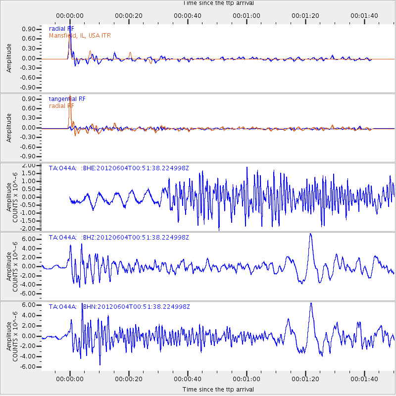
Signal To Noise
| Channel | StoN | STA | LTA |
| TA:O44A: :BHZ:20120604T00:51:38.224998Z | 9.848687 | 2.6534872E-6 | 2.6942547E-7 |
| TA:O44A: :BHN:20120604T00:51:38.224998Z | 13.552279 | 2.3825282E-6 | 1.7580277E-7 |
| TA:O44A: :BHE:20120604T00:51:38.224998Z | 2.060037 | 5.475458E-7 | 2.657942E-7 |
| Arrivals |
| Ps | 1.4 SECOND |
| PpPs | 5.0 SECOND |
| PsPs/PpSs | 6.3 SECOND |


