You are here: Home > Network List > G - GEOSCOPE Stations List
> Station SCZ Chualar Canyon, Santa Cruz, California, U.S.A. > Earthquake Result Viewer
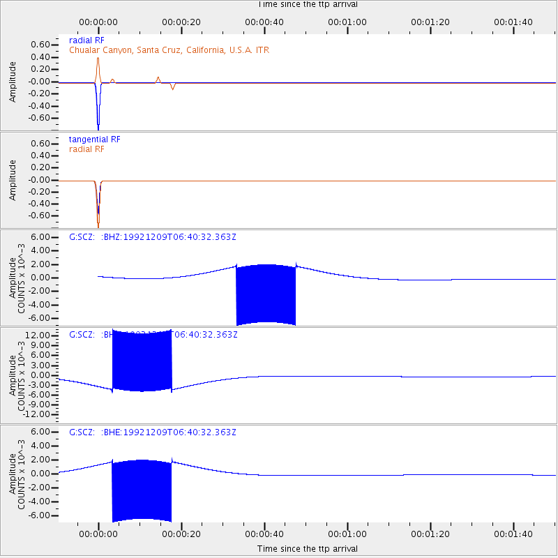
SCZ Chualar Canyon, Santa Cruz, California, U.S.A. - Earthquake Result Viewer
*The percent match for this event was below the threshold and hence no stack was calculated.
| Earthquake location: |
Pacific-Antarctic Ridge |
| Earthquake latitude/longitude: |
-56.5/-142.6 |
| Earthquake time(UTC): |
1992/12/09 (344) 06:27:43 GMT |
| Earthquake Depth: |
10 km |
| Earthquake Magnitude: |
5.8 MB, 5.5 MS |
| Earthquake Catalog/Contributor: |
WHDF/NEIC |
|
| Network: |
G GEOSCOPE |
| Station: |
SCZ Chualar Canyon, Santa Cruz, California, U.S.A. |
| Lat/Lon: |
36.60 N/121.40 W |
| Elevation: |
261 m |
|
| Distance: |
94.5 deg |
| Az: |
16.971 deg |
| Baz: |
191.589 deg |
| Ray Param: |
$rayparam |
*The percent match for this event was below the threshold and hence was not used in the summary stack. |
|
| Radial Match: |
99.99586 % |
| Radial Bump: |
2 |
| Transverse Match: |
99.99297 % |
| Transverse Bump: |
2 |
| SOD ConfigId: |
4480 |
| Insert Time: |
2010-02-26 23:57:00.989 +0000 |
| GWidth: |
2.5 |
| Max Bumps: |
400 |
| Tol: |
0.001 |
|
Signal To Noise
| Channel | StoN | STA | LTA |
| G:SCZ: :BHN:19921209T06:40:32.363Z | 12.305643 | 0.004858378 | 3.9480894E-4 |
| G:SCZ: :BHE:19921209T06:40:32.363Z | 11.958416 | 0.0022328286 | 1.8671609E-4 |
| G:SCZ: :BHZ:19921209T06:40:32.363Z | 12.331844 | 0.0023562054 | 1.9106673E-4 |
| Arrivals |
| Ps | |
| PpPs | |
| PsPs/PpSs | |


