You are here: Home > Network List > TA - USArray Transportable Network (new EarthScope stations) Stations List
> Station Q47A Bedord North Lawrence Stars, Bedford, IN, USA > Earthquake Result Viewer
Q47A Bedord North Lawrence Stars, Bedford, IN, USA - Earthquake Result Viewer

| Earthquake location: |
South Of Panama |
| Earthquake latitude/longitude: |
5.3/-82.6 |
| Earthquake time(UTC): |
2012/06/04 (156) 00:45:15 GMT |
| Earthquake Depth: |
7.0 km |
| Earthquake Magnitude: |
5.9 MB, 5.9 MS, 6.3 MW, 6.2 MW |
| Earthquake Catalog/Contributor: |
WHDF/NEIC |
|
| Network: |
TA USArray Transportable Network (new EarthScope stations) |
| Station: |
Q47A Bedord North Lawrence Stars, Bedford, IN, USA |
| Lat/Lon: |
38.94 N/86.43 W |
| Elevation: |
230 m |
|
| Distance: |
33.7 deg |
| Az: |
354.653 deg |
| Baz: |
173.166 deg |
| Ray Param: |
0.078113884 |
| Estimated Moho Depth: |
57.5 km |
| Estimated Crust Vp/Vs: |
1.85 |
| Assumed Crust Vp: |
6.444 km/s |
| Estimated Crust Vs: |
3.493 km/s |
| Estimated Crust Poisson's Ratio: |
0.29 |
|
| Radial Match: |
84.44966 % |
| Radial Bump: |
332 |
| Transverse Match: |
66.1434 % |
| Transverse Bump: |
400 |
| SOD ConfigId: |
458385 |
| Insert Time: |
2012-10-16 08:36:51.969 +0000 |
| GWidth: |
2.5 |
| Max Bumps: |
400 |
| Tol: |
0.001 |
|
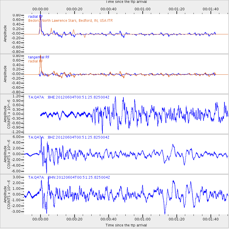
Signal To Noise
| Channel | StoN | STA | LTA |
| TA:Q47A: :BHZ:20120604T00:51:25.825004Z | 14.157005 | 2.7182516E-6 | 1.9200753E-7 |
| TA:Q47A: :BHN:20120604T00:51:25.825004Z | 8.102259 | 1.5492406E-6 | 1.9121094E-7 |
| TA:Q47A: :BHE:20120604T00:51:25.825004Z | 2.9487398 | 3.2522505E-7 | 1.10292895E-7 |
| Arrivals |
| Ps | 8.1 SECOND |
| PpPs | 24 SECOND |
| PsPs/PpSs | 32 SECOND |


