You are here: Home > Network List > TA - USArray Transportable Network (new EarthScope stations) Stations List
> Station Q45A Warren Harvey, Newton, IL, USA > Earthquake Result Viewer
Q45A Warren Harvey, Newton, IL, USA - Earthquake Result Viewer

| Earthquake location: |
South Of Panama |
| Earthquake latitude/longitude: |
5.3/-82.6 |
| Earthquake time(UTC): |
2012/06/04 (156) 00:45:15 GMT |
| Earthquake Depth: |
7.0 km |
| Earthquake Magnitude: |
5.9 MB, 5.9 MS, 6.3 MW, 6.2 MW |
| Earthquake Catalog/Contributor: |
WHDF/NEIC |
|
| Network: |
TA USArray Transportable Network (new EarthScope stations) |
| Station: |
Q45A Warren Harvey, Newton, IL, USA |
| Lat/Lon: |
38.89 N/88.16 W |
| Elevation: |
162 m |
|
| Distance: |
33.8 deg |
| Az: |
352.237 deg |
| Baz: |
170.074 deg |
| Ray Param: |
0.078042105 |
| Estimated Moho Depth: |
14.25 km |
| Estimated Crust Vp/Vs: |
2.10 |
| Assumed Crust Vp: |
6.444 km/s |
| Estimated Crust Vs: |
3.072 km/s |
| Estimated Crust Poisson's Ratio: |
0.35 |
|
| Radial Match: |
88.58077 % |
| Radial Bump: |
400 |
| Transverse Match: |
49.733353 % |
| Transverse Bump: |
400 |
| SOD ConfigId: |
458385 |
| Insert Time: |
2012-10-16 08:37:18.479 +0000 |
| GWidth: |
2.5 |
| Max Bumps: |
400 |
| Tol: |
0.001 |
|
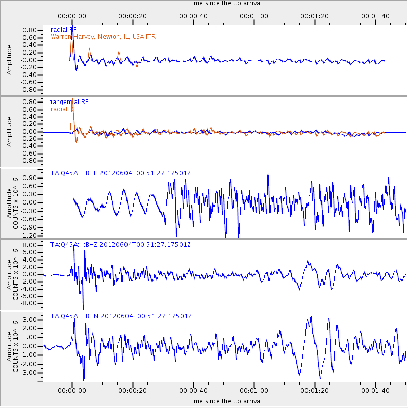
Signal To Noise
| Channel | StoN | STA | LTA |
| TA:Q45A: :BHZ:20120604T00:51:27.17501Z | 15.680162 | 3.5347311E-6 | 2.2542694E-7 |
| TA:Q45A: :BHN:20120604T00:51:27.17501Z | 8.939791 | 1.5976048E-6 | 1.7870718E-7 |
| TA:Q45A: :BHE:20120604T00:51:27.17501Z | 2.2576983 | 5.555527E-7 | 2.4607036E-7 |
| Arrivals |
| Ps | 2.6 SECOND |
| PpPs | 6.4 SECOND |
| PsPs/PpSs | 9.0 SECOND |


