You are here: Home > Network List > CI - Caltech Regional Seismic Network Stations List
> Station LGU LGU, Camarillo, CA, USA > Earthquake Result Viewer
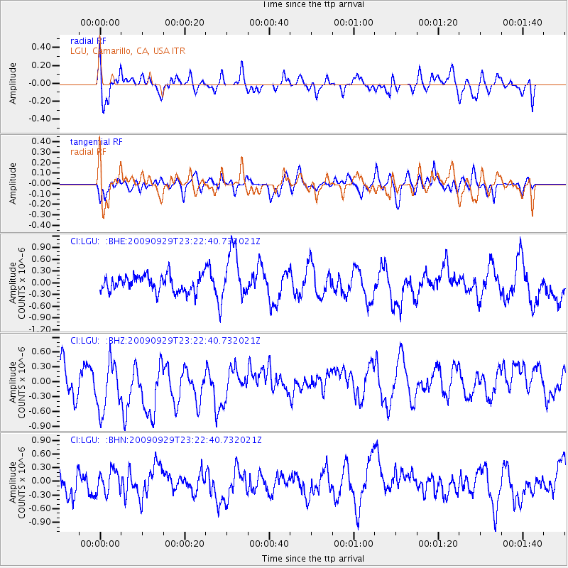
LGU LGU, Camarillo, CA, USA - Earthquake Result Viewer
*The percent match for this event was below the threshold and hence no stack was calculated.
| Earthquake location: |
Tonga Islands |
| Earthquake latitude/longitude: |
-15.6/-173.4 |
| Earthquake time(UTC): |
2009/09/29 (272) 23:11:51 GMT |
| Earthquake Depth: |
10 km |
| Earthquake Magnitude: |
5.5 MB |
| Earthquake Catalog/Contributor: |
WHDF/NEIC |
|
| Network: |
CI Caltech Regional Seismic Network |
| Station: |
LGU LGU, Camarillo, CA, USA |
| Lat/Lon: |
34.11 N/119.07 W |
| Elevation: |
416 m |
|
| Distance: |
71.5 deg |
| Az: |
45.281 deg |
| Baz: |
235.61 deg |
| Ray Param: |
$rayparam |
*The percent match for this event was below the threshold and hence was not used in the summary stack. |
|
| Radial Match: |
26.733063 % |
| Radial Bump: |
400 |
| Transverse Match: |
59.164143 % |
| Transverse Bump: |
400 |
| SOD ConfigId: |
2622 |
| Insert Time: |
2010-02-25 20:22:40.415 +0000 |
| GWidth: |
2.5 |
| Max Bumps: |
400 |
| Tol: |
0.001 |
|
Signal To Noise
| Channel | StoN | STA | LTA |
| CI:LGU: :BHZ:20090929T23:22:40.732021Z | 1.2796699 | 7.904565E-7 | 6.1770345E-7 |
| CI:LGU: :BHN:20090929T23:22:40.732021Z | 0.74938464 | 2.8476322E-7 | 3.799961E-7 |
| CI:LGU: :BHE:20090929T23:22:40.732021Z | 2.9918551 | 6.2231766E-7 | 2.0800394E-7 |
| Arrivals |
| Ps | |
| PpPs | |
| PsPs/PpSs | |


