You are here: Home > Network List > TA - USArray Transportable Network (new EarthScope stations) Stations List
> Station U47A Clarksville, TN, USA > Earthquake Result Viewer
U47A Clarksville, TN, USA - Earthquake Result Viewer
| Earthquake location: |
South Of Panama |
| Earthquake latitude/longitude: |
5.3/-82.6 |
| Earthquake time(UTC): |
2012/06/04 (156) 00:45:15 GMT |
| Earthquake Depth: |
7.0 km |
| Earthquake Magnitude: |
5.9 MB, 5.9 MS, 6.3 MW, 6.2 MW |
| Earthquake Catalog/Contributor: |
WHDF/NEIC |
|
| Network: |
TA USArray Transportable Network (new EarthScope stations) |
| Station: |
U47A Clarksville, TN, USA |
| Lat/Lon: |
36.44 N/87.29 W |
| Elevation: |
145 m |
|
| Distance: |
31.3 deg |
| Az: |
352.752 deg |
| Baz: |
171.036 deg |
| Ray Param: |
0.079114 |
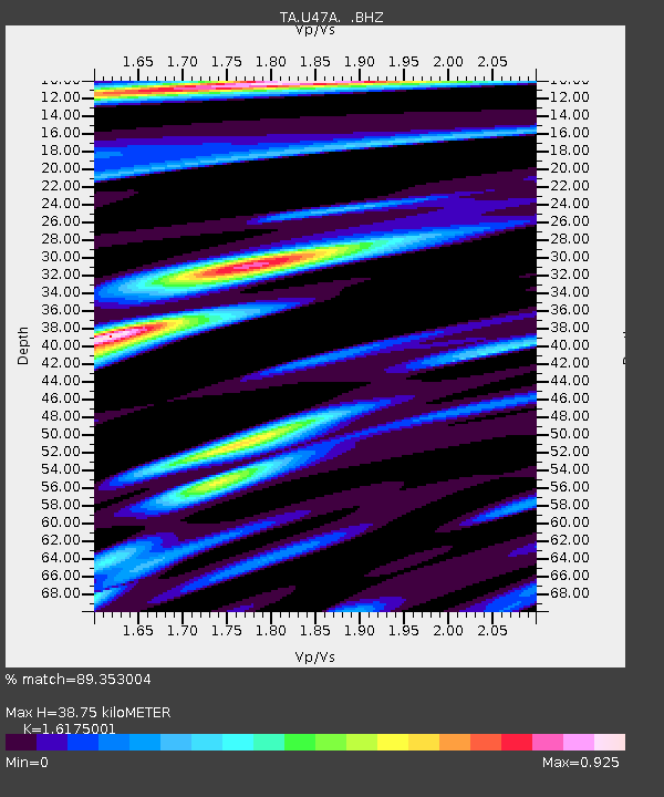
| Estimated Moho Depth: |
38.75 km |
| Estimated Crust Vp/Vs: |
1.62 |
| Assumed Crust Vp: |
6.444 km/s |
| Estimated Crust Vs: |
3.984 km/s |
| Estimated Crust Poisson's Ratio: |
0.19 |
|
| Radial Match: |
89.353004 % |
| Radial Bump: |
346 |
| Transverse Match: |
61.663666 % |
| Transverse Bump: |
400 |
| SOD ConfigId: |
458385 |
| Insert Time: |
2012-10-16 08:37:59.853 +0000 |
| GWidth: |
2.5 |
| Max Bumps: |
400 |
| Tol: |
0.001 |
|

Signal To Noise
| Channel | StoN | STA | LTA |
| TA:U47A: :BHZ:20120604T00:51:05.099998Z | 9.223142 | 1.5170291E-6 | 1.6448072E-7 |
| TA:U47A: :BHN:20120604T00:51:05.099998Z | 7.565136 | 1.01787E-6 | 1.3454748E-7 |
| TA:U47A: :BHE:20120604T00:51:05.099998Z | 1.512382 | 1.3241055E-7 | 8.7550994E-8 |
| Arrivals |
| Ps | 4.1 SECOND |
| PpPs | 14 SECOND |
| PsPs/PpSs | 18 SECOND |


