You are here: Home > Network List > TA - USArray Transportable Network (new EarthScope stations) Stations List
> Station V47A Nunnelly, TN, USA > Earthquake Result Viewer
V47A Nunnelly, TN, USA - Earthquake Result Viewer

| Earthquake location: |
South Of Panama |
| Earthquake latitude/longitude: |
5.3/-82.6 |
| Earthquake time(UTC): |
2012/06/04 (156) 00:45:15 GMT |
| Earthquake Depth: |
7.0 km |
| Earthquake Magnitude: |
5.9 MB, 5.9 MS, 6.3 MW, 6.2 MW |
| Earthquake Catalog/Contributor: |
WHDF/NEIC |
|
| Network: |
TA USArray Transportable Network (new EarthScope stations) |
| Station: |
V47A Nunnelly, TN, USA |
| Lat/Lon: |
35.83 N/87.52 W |
| Elevation: |
240 m |
|
| Distance: |
30.7 deg |
| Az: |
352.201 deg |
| Baz: |
170.429 deg |
| Ray Param: |
0.07926483 |
| Estimated Moho Depth: |
52.75 km |
| Estimated Crust Vp/Vs: |
2.05 |
| Assumed Crust Vp: |
6.476 km/s |
| Estimated Crust Vs: |
3.163 km/s |
| Estimated Crust Poisson's Ratio: |
0.34 |
|
| Radial Match: |
91.371826 % |
| Radial Bump: |
316 |
| Transverse Match: |
69.027664 % |
| Transverse Bump: |
400 |
| SOD ConfigId: |
458385 |
| Insert Time: |
2012-10-16 08:38:25.795 +0000 |
| GWidth: |
2.5 |
| Max Bumps: |
400 |
| Tol: |
0.001 |
|
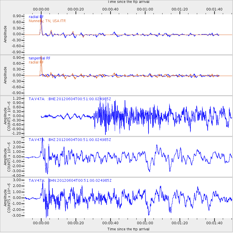
Signal To Noise
| Channel | StoN | STA | LTA |
| TA:V47A: :BHZ:20120604T00:51:00.024985Z | 15.700015 | 1.9437775E-6 | 1.2380737E-7 |
| TA:V47A: :BHN:20120604T00:51:00.024985Z | 9.438557 | 1.3536096E-6 | 1.4341279E-7 |
| TA:V47A: :BHE:20120604T00:51:00.024985Z | 4.542207 | 3.7402248E-7 | 8.234379E-8 |
| Arrivals |
| Ps | 9.2 SECOND |
| PpPs | 23 SECOND |
| PsPs/PpSs | 32 SECOND |


