You are here: Home > Network List > TA - USArray Transportable Network (new EarthScope stations) Stations List
> Station V46A Holladay, TN, USA > Earthquake Result Viewer
V46A Holladay, TN, USA - Earthquake Result Viewer
| Earthquake location: |
South Of Panama |
| Earthquake latitude/longitude: |
5.3/-82.6 |
| Earthquake time(UTC): |
2012/06/04 (156) 00:45:15 GMT |
| Earthquake Depth: |
7.0 km |
| Earthquake Magnitude: |
5.9 MB, 5.9 MS, 6.3 MW, 6.2 MW |
| Earthquake Catalog/Contributor: |
WHDF/NEIC |
|
| Network: |
TA USArray Transportable Network (new EarthScope stations) |
| Station: |
V46A Holladay, TN, USA |
| Lat/Lon: |
35.80 N/88.12 W |
| Elevation: |
162 m |
|
| Distance: |
30.8 deg |
| Az: |
351.257 deg |
| Baz: |
169.269 deg |
| Ray Param: |
0.079249345 |
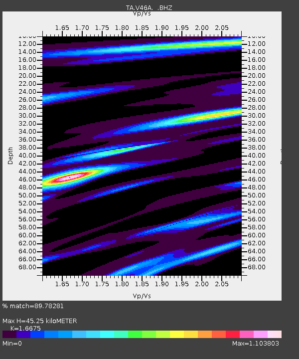
| Estimated Moho Depth: |
45.25 km |
| Estimated Crust Vp/Vs: |
1.67 |
| Assumed Crust Vp: |
6.38 km/s |
| Estimated Crust Vs: |
3.826 km/s |
| Estimated Crust Poisson's Ratio: |
0.22 |
|
| Radial Match: |
89.78281 % |
| Radial Bump: |
374 |
| Transverse Match: |
65.178116 % |
| Transverse Bump: |
400 |
| SOD ConfigId: |
458385 |
| Insert Time: |
2012-10-16 08:38:28.703 +0000 |
| GWidth: |
2.5 |
| Max Bumps: |
400 |
| Tol: |
0.001 |
|

Signal To Noise
| Channel | StoN | STA | LTA |
| TA:V46A: :BHZ:20120604T00:51:00.55001Z | 9.813543 | 1.5934128E-6 | 1.6236875E-7 |
| TA:V46A: :BHN:20120604T00:51:00.55001Z | 11.190903 | 1.0110712E-6 | 9.03476E-8 |
| TA:V46A: :BHE:20120604T00:51:00.55001Z | 1.5830733 | 2.1328738E-7 | 1.3472994E-7 |
| Arrivals |
| Ps | 5.2 SECOND |
| PpPs | 17 SECOND |
| PsPs/PpSs | 23 SECOND |


