You are here: Home > Network List > TA - USArray Transportable Network (new EarthScope stations) Stations List
> Station V50A Pikevile, TN, USA > Earthquake Result Viewer
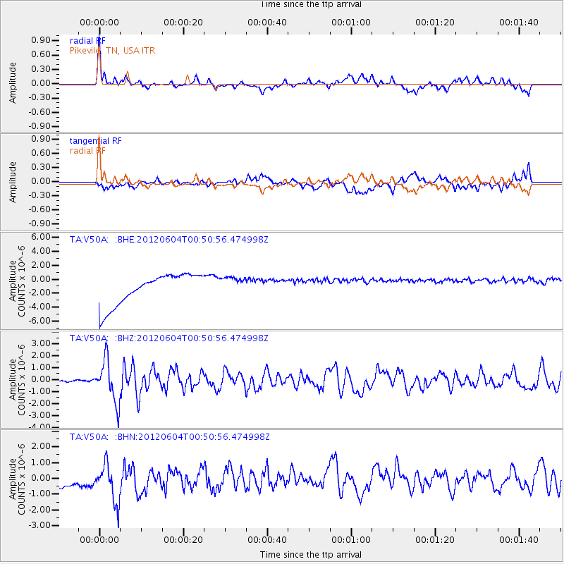
V50A Pikevile, TN, USA - Earthquake Result Viewer
*The percent match for this event was below the threshold and hence no stack was calculated.
| Earthquake location: |
South Of Panama |
| Earthquake latitude/longitude: |
5.3/-82.6 |
| Earthquake time(UTC): |
2012/06/04 (156) 00:45:15 GMT |
| Earthquake Depth: |
7.0 km |
| Earthquake Magnitude: |
5.9 MB, 5.9 MS, 6.3 MW, 6.2 MW |
| Earthquake Catalog/Contributor: |
WHDF/NEIC |
|
| Network: |
TA USArray Transportable Network (new EarthScope stations) |
| Station: |
V50A Pikevile, TN, USA |
| Lat/Lon: |
35.67 N/85.10 W |
| Elevation: |
287 m |
|
| Distance: |
30.3 deg |
| Az: |
356.011 deg |
| Baz: |
175.119 deg |
| Ray Param: |
$rayparam |
*The percent match for this event was below the threshold and hence was not used in the summary stack. |
|
| Radial Match: |
35.19995 % |
| Radial Bump: |
400 |
| Transverse Match: |
15.01194 % |
| Transverse Bump: |
400 |
| SOD ConfigId: |
458385 |
| Insert Time: |
2012-10-16 08:39:03.623 +0000 |
| GWidth: |
2.5 |
| Max Bumps: |
400 |
| Tol: |
0.001 |
|
Signal To Noise
| Channel | StoN | STA | LTA |
| TA:V50A: :BHZ:20120604T00:50:56.474998Z | 9.62026 | 1.8193647E-6 | 1.8911804E-7 |
| TA:V50A: :BHN:20120604T00:50:56.474998Z | 1.0845602 | 1.5933207E-6 | 1.4690938E-6 |
| TA:V50A: :BHE:20120604T00:50:56.474998Z | 0.6266695 | 1.3866879E-6 | 2.21279E-6 |
| Arrivals |
| Ps | |
| PpPs | |
| PsPs/PpSs | |


