You are here: Home > Network List > TA - USArray Transportable Network (new EarthScope stations) Stations List
> Station V53A Saluda, NC, USA > Earthquake Result Viewer
V53A Saluda, NC, USA - Earthquake Result Viewer

| Earthquake location: |
South Of Panama |
| Earthquake latitude/longitude: |
5.3/-82.6 |
| Earthquake time(UTC): |
2012/06/04 (156) 00:45:15 GMT |
| Earthquake Depth: |
7.0 km |
| Earthquake Magnitude: |
5.9 MB, 5.9 MS, 6.3 MW, 6.2 MW |
| Earthquake Catalog/Contributor: |
WHDF/NEIC |
|
| Network: |
TA USArray Transportable Network (new EarthScope stations) |
| Station: |
V53A Saluda, NC, USA |
| Lat/Lon: |
35.67 N/82.81 W |
| Elevation: |
681 m |
|
| Distance: |
30.2 deg |
| Az: |
359.703 deg |
| Baz: |
179.637 deg |
| Ray Param: |
0.079393536 |
| Estimated Moho Depth: |
42.5 km |
| Estimated Crust Vp/Vs: |
1.79 |
| Assumed Crust Vp: |
6.35 km/s |
| Estimated Crust Vs: |
3.543 km/s |
| Estimated Crust Poisson's Ratio: |
0.27 |
|
| Radial Match: |
87.87775 % |
| Radial Bump: |
251 |
| Transverse Match: |
67.75589 % |
| Transverse Bump: |
400 |
| SOD ConfigId: |
458385 |
| Insert Time: |
2012-10-16 08:39:35.225 +0000 |
| GWidth: |
2.5 |
| Max Bumps: |
400 |
| Tol: |
0.001 |
|
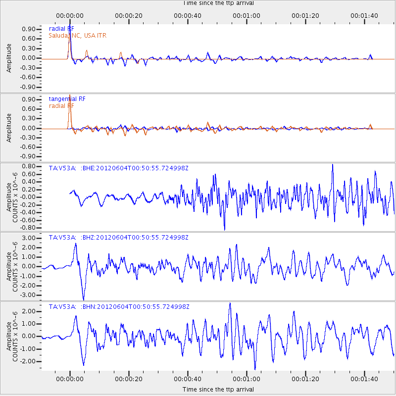
Signal To Noise
| Channel | StoN | STA | LTA |
| TA:V53A: :BHZ:20120604T00:50:55.724998Z | 12.047162 | 1.5209384E-6 | 1.262487E-7 |
| TA:V53A: :BHN:20120604T00:50:55.724998Z | 11.939981 | 1.0391508E-6 | 8.703119E-8 |
| TA:V53A: :BHE:20120604T00:50:55.724998Z | 0.8918749 | 8.373663E-8 | 9.388831E-8 |
| Arrivals |
| Ps | 5.7 SECOND |
| PpPs | 17 SECOND |
| PsPs/PpSs | 23 SECOND |


