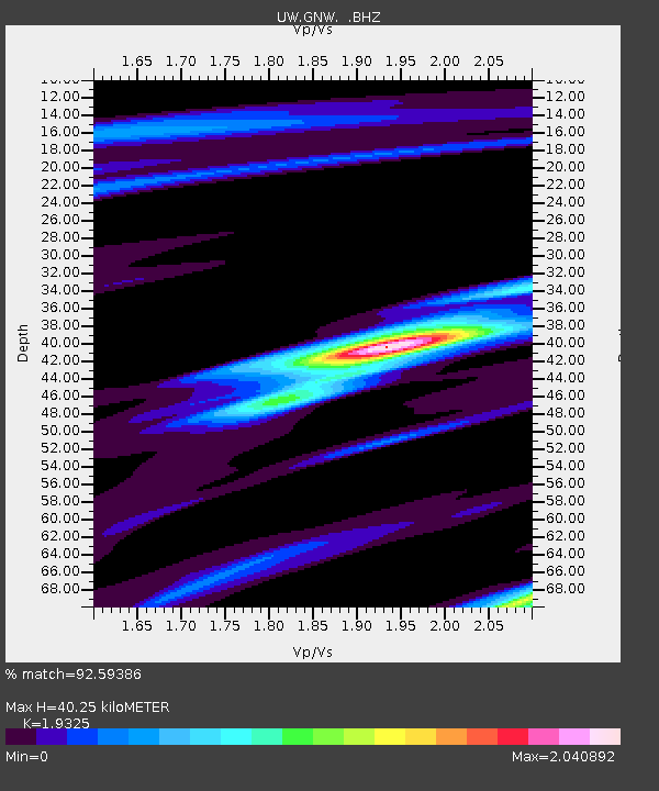
GNW Green Mountain (BB) - Earthquake Result Viewer
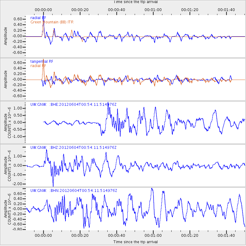
Earthquake location: South Of Panama
Earthquake latitude/longitude: 5.3/-82.6
Earthquake time(UTC): 2012/06/04 (156) 00:45:15 GMT
Earthquake Depth: 7.0 km
Earthquake Magnitude: 5.9 MB, 5.9 MS, 6.3 MW, 6.2 MW
Earthquake Catalog/Contributor: WHDF/NEIC
Network: UW Pacific Northwest Regional Seismic Network
Station: GNW Green Mountain (BB)
Lat/Lon: 47.56 N/122.83 W
Elevation: 160 m
Distance: 54.4 deg
Az: 327.465 deg
Baz: 127.74 deg
Ray Param: 0.06550319
Estimated Moho Depth: 40.25 km
Estimated Crust Vp/Vs: 1.93
Assumed Crust Vp: 6.566 km/s
Estimated Crust Vs: 3.398 km/s
Estimated Crust Poisson's Ratio: 0.32
Radial Match: 92.59386 %
Radial Bump: 400
Transverse Match: 81.33774 %
Transverse Bump: 400
SOD ConfigId: 458385
Insert Time: 2012-10-16 08:40:51.403 +0000
GWidth: 2.5
Max Bumps: 400
Tol: 0.001

Signal To Noise

ChannelStoNSTALTA
UW:GNW: :BHZ:20120604T00:54:11.514976Z11.0508177.2998563E-76.605717E-8
UW:GNW: :BHN:20120604T00:54:11.514976Z1.63730681.7771964E-71.0854388E-7
UW:GNW: :BHE:20120604T00:54:11.514976Z5.66794974.6417566E-78.189481E-8
Arrivals
Ps6.0 SECOND
PpPs17 SECOND
PsPs/PpSs23 SECOND