You are here: Home > Network List > IW - Intermountain West Stations List
> Station RWWY Rawlins, Wyoming, USA > Earthquake Result Viewer
RWWY Rawlins, Wyoming, USA - Earthquake Result Viewer
| Earthquake location: |
South Of Panama |
| Earthquake latitude/longitude: |
5.5/-82.6 |
| Earthquake time(UTC): |
2012/06/04 (156) 03:15:24 GMT |
| Earthquake Depth: |
7.0 km |
| Earthquake Magnitude: |
5.8 MB, 5.8 MS, 6.3 MW, 6.1 MW |
| Earthquake Catalog/Contributor: |
WHDF/NEIC |
|
| Network: |
IW Intermountain West |
| Station: |
RWWY Rawlins, Wyoming, USA |
| Lat/Lon: |
41.69 N/107.21 W |
| Elevation: |
2402 m |
|
| Distance: |
42.2 deg |
| Az: |
332.289 deg |
| Baz: |
141.828 deg |
| Ray Param: |
0.07331951 |
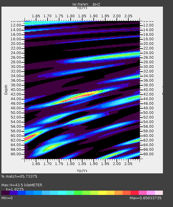
| Estimated Moho Depth: |
43.5 km |
| Estimated Crust Vp/Vs: |
1.82 |
| Assumed Crust Vp: |
6.159 km/s |
| Estimated Crust Vs: |
3.379 km/s |
| Estimated Crust Poisson's Ratio: |
0.28 |
|
| Radial Match: |
85.73375 % |
| Radial Bump: |
400 |
| Transverse Match: |
75.2384 % |
| Transverse Bump: |
400 |
| SOD ConfigId: |
458385 |
| Insert Time: |
2012-10-16 08:52:22.523 +0000 |
| GWidth: |
2.5 |
| Max Bumps: |
400 |
| Tol: |
0.001 |
|

Signal To Noise
| Channel | StoN | STA | LTA |
| IW:RWWY: :BHZ:20120604T03:22:47.244995Z | 5.291421 | 9.4236026E-7 | 1.780921E-7 |
| IW:RWWY: :BHN:20120604T03:22:47.244995Z | 2.1983247 | 3.3753585E-7 | 1.535423E-7 |
| IW:RWWY: :BHE:20120604T03:22:47.244995Z | 1.2291353 | 1.8015932E-7 | 1.4657404E-7 |
| Arrivals |
| Ps | 6.2 SECOND |
| PpPs | 19 SECOND |
| PsPs/PpSs | 25 SECOND |


