You are here: Home > Network List > TA - USArray Transportable Network (new EarthScope stations) Stations List
> Station T25A Trinidad, CO, USA > Earthquake Result Viewer
T25A Trinidad, CO, USA - Earthquake Result Viewer

| Earthquake location: |
South Of Panama |
| Earthquake latitude/longitude: |
5.5/-82.6 |
| Earthquake time(UTC): |
2012/06/04 (156) 03:15:24 GMT |
| Earthquake Depth: |
7.0 km |
| Earthquake Magnitude: |
5.8 MB, 5.8 MS, 6.3 MW, 6.1 MW |
| Earthquake Catalog/Contributor: |
WHDF/NEIC |
|
| Network: |
TA USArray Transportable Network (new EarthScope stations) |
| Station: |
T25A Trinidad, CO, USA |
| Lat/Lon: |
37.14 N/104.41 W |
| Elevation: |
2017 m |
|
| Distance: |
37.3 deg |
| Az: |
330.597 deg |
| Baz: |
142.297 deg |
| Ray Param: |
0.07622824 |
| Estimated Moho Depth: |
33.5 km |
| Estimated Crust Vp/Vs: |
1.60 |
| Assumed Crust Vp: |
6.316 km/s |
| Estimated Crust Vs: |
3.947 km/s |
| Estimated Crust Poisson's Ratio: |
0.18 |
|
| Radial Match: |
90.34719 % |
| Radial Bump: |
247 |
| Transverse Match: |
75.825554 % |
| Transverse Bump: |
379 |
| SOD ConfigId: |
458385 |
| Insert Time: |
2012-10-16 08:56:33.435 +0000 |
| GWidth: |
2.5 |
| Max Bumps: |
400 |
| Tol: |
0.001 |
|
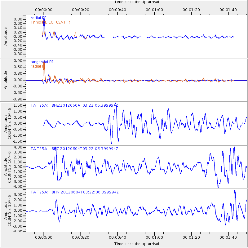
Signal To Noise
| Channel | StoN | STA | LTA |
| TA:T25A: :BHZ:20120604T03:22:06.399994Z | 2.4668045 | 6.014853E-7 | 2.4383178E-7 |
| TA:T25A: :BHN:20120604T03:22:06.399994Z | 1.359294 | 1.9339853E-7 | 1.4227867E-7 |
| TA:T25A: :BHE:20120604T03:22:06.399994Z | 1.8140883 | 2.760913E-7 | 1.5219287E-7 |
| Arrivals |
| Ps | 3.4 SECOND |
| PpPs | 13 SECOND |
| PsPs/PpSs | 16 SECOND |


